One More Time
 Iron Creek Transfer Camp - snow a little lower than I expected
I thought that my last backpacking trip to Thompson Peak was the end of the hiking season. We had incredibly nice weather for late October. But after we got home the weather changed. It rained in Boise. Since our irrigation water had been turned off early this year, I had to admit that "we needed the rain". That's something I rarely say - I'm a big fan of clear skies and nice weather all the time. I really would live in Southern California if a gazillion people weren't there already. The cool temperatures and rain in Boise though meant cold and snow in the high country. After five days the weather lifted enough to see the mountains and even Shafer Butte had a lot of snow on it - the snowline came down to about six thousand feet. Once the weather turns bad this time of year it tends to stay bad until next spring, so I figured that was it for hiking in the mountains this season.
It turns out that I was wrong. The weather cleared up and it was warm again - we were in the sixties in Boise. In a day the snow at Bogus Basin melted and I began to get optimistic that another hike might still be possible. I figured out a day that I would be clear to go. I checked the Stanley webcam and could see that there was a lot of snow in the mountains but none in the valley. I called the Forest Service but strangely enough they had no idea of trail conditions. I decided I would just give it a try. My plan was to hike to Sawtooth Lake. That is my favorite hike in the Sawtooths and one that I have done more than any other hike. I usually try to go every year. So I know the trail very well and figured I could follow it even if I hit some snow. And even if I didn't make it all the way to Sawtooth Lake there is a nice view of Alpine Lake about two thirds of the way up.
 Hey Dave - does this spot look familiar?
I had no idea what level the snow line was. I didn't even know if the road was clear all the way to Stanley. Sure enough, when I was going over Banner Summit (about 7000 feet) on the way to Stanley, there was snow along the side of the road. The pavement was clear but if there was snow this low I didn't expect that I would make it to Sawtooth Lake at over 8400 feet. But I figured I would get as high as I could. It would turn out that it wasn't very high.
I had another problem as well. At Garden Valley I had hit fog. Not bad for driving so I wasn't worried. Garden Valley is in a valley (duh!), it was early, and so fog wasn't too surprising. But the fog continued all the way to Stanley - the route pretty much follows the South Fork of the Payette River. But the forecast was for sunny skies so I assumed it would burn off - eventually.
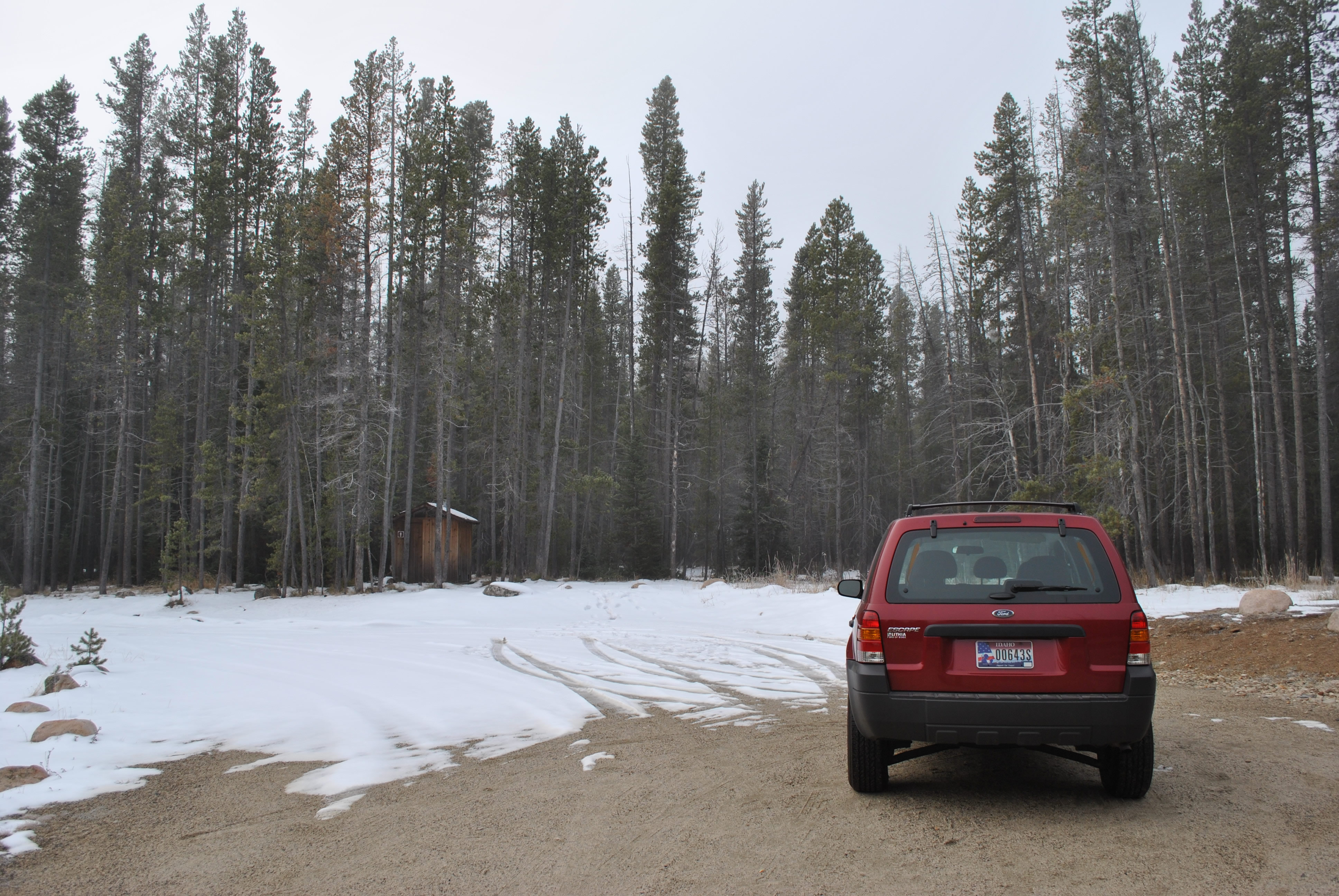
I reached the turnoff for the Iron Creek Transfer Camp just before Stanley. From the main highway there is four miles on a good dirt road which climbs very gradually to where the trail starts. About half way there I came around a corner and clear road turned completely to snow floor. Usually it is a gradual process but not this time. There were a lot of tracks where other people had driven on it so I kept going. After a while I began to get nervous as there was enough snow that it would be tough to turn around. The easiest going was in the tracks. All I needed to do was get stuck a couple of miles from the highway. It would be about a two hour walk to Stanley! But I made it to the trailhead without any trouble and was able to park. I could see the trail but there was patchy snow on it. Since the first two miles climb through forest I figured I would be lucky to get more than a couple of hundred yards before I would have to turn back. So my hike was over before it started.
 Horstman Peak and Mt. Ebert with new snowfall
Time for Plan B. I drove into Stanley and asked the lady at the gas station about the fog. She said that the day before it had cleared up at about eleven. It was ten now. Since I left home without eating any breakfast, I went across the street to the Mountain Village restaurant where I figured that I could kill some time while eating brunch. That would give me a chance to see if the fog would lift. Even if I couldn't hike I could still get some pictures from the valley. I ordered a grilled cheese sandwich (which was actually on the kiddie menu - good thing that they didn't card me).
I was done in about forty five minutes and there wasn't any sign that the fog was lifting. I decided that I would take the southern route home through Sun Valley. That goes over Galena Summit at the southern end of the Stanley Valley. At eight thousand feet it is the highest paved road in Idaho. There is a nice view of the Sawtooths from near the top. I figured that at least that viewpoint had to be above the fog and I would be able to see something.
I started to drive south and just past the Redfish Lake turnoff the fog started to thin. In about two more miles I came partially out of the fog and had my first view of the peaks. Sure enough there was only about a two hundred foot layer of fog in the valley. The mountains were in the sunshine. They had a lot of new snow on them. As many times as I have been to the Sawtooths this was a different view of them for me. I decided to double back a few miles and see if Redfish Lake was clearing. There would be some good shots of mountains and clouds if it was.
 View of Mt. Heyburn emerges from the fog
When I reached Redfish Lake it was completely socked in. But here there wasn't any snow on the ground. I went to the backpacker parking lot. It was deja vu - this is where my last backpacking trip had started exactly two weeks before. After a very short hike up Fishhook Creek the trail climbs quickly several hundred feet to the top of the ridge on the north side of the Fishhook Creek drainage. If I could get that far without being stopped by snow I was guessing that I would be above the fog. I left my pack in the car, grabbed my camera, and headed up the trail.
There is a sign in station right at the trailhead. My name was there from the trip two weeks before. There were only four people who had hiked this trail in the two weeks since then. Even though the weather had been bad part of the time, that isn't very many people for the most popular trailhead in the Sawtooths.
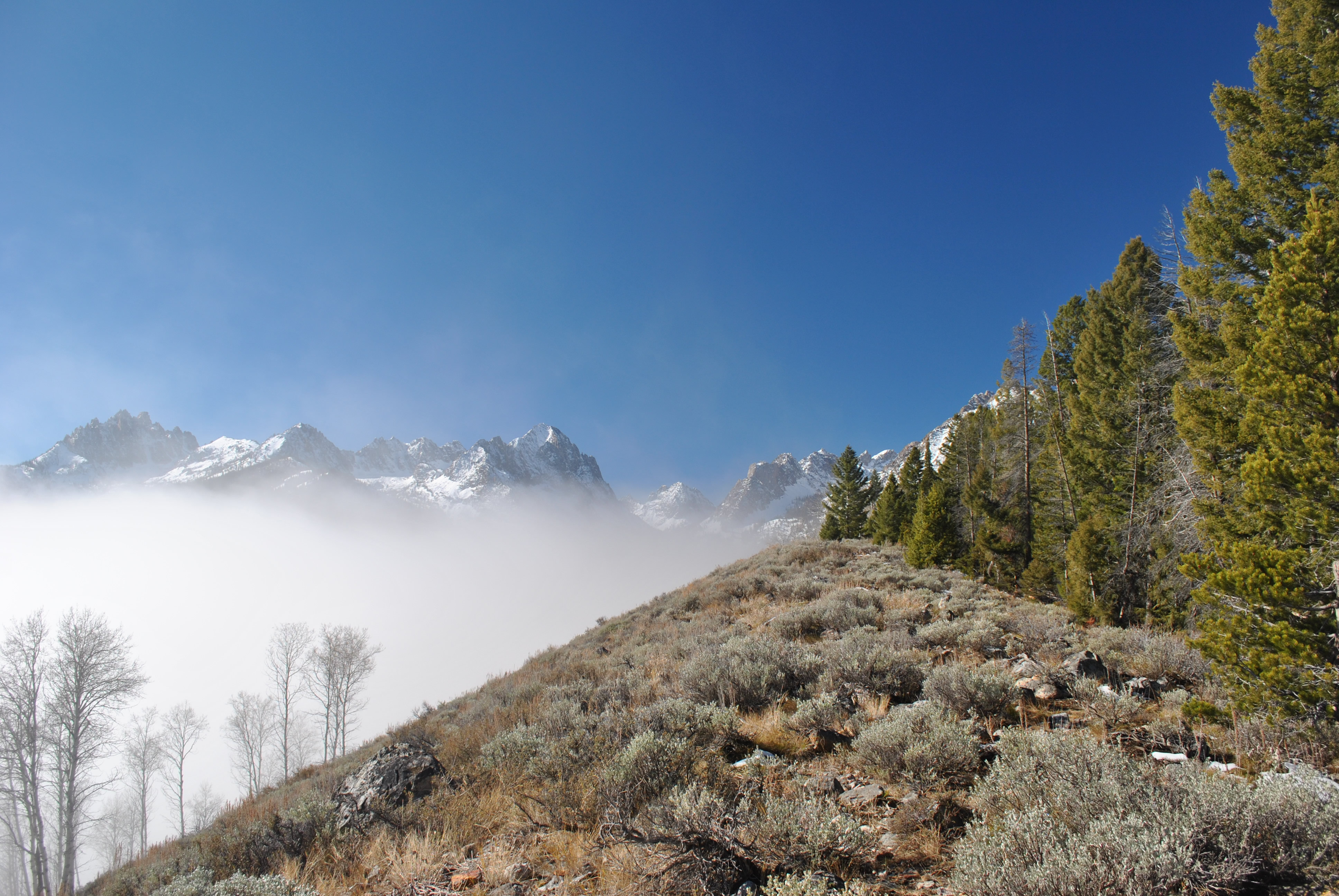
I started to climb but the fog didn't seem to be thinning out. It still looked like it was continuting quite a way above me up the ridge too. If I didn't get any pictures here I needed to get to Galena Summit before it got too late in the afternoon and the light wasn't good. So I was hustling up the ridge to see if I came out of the clouds. Not a long hike but at least it was a really good workout.
 Fog clearing at Redfish Lake
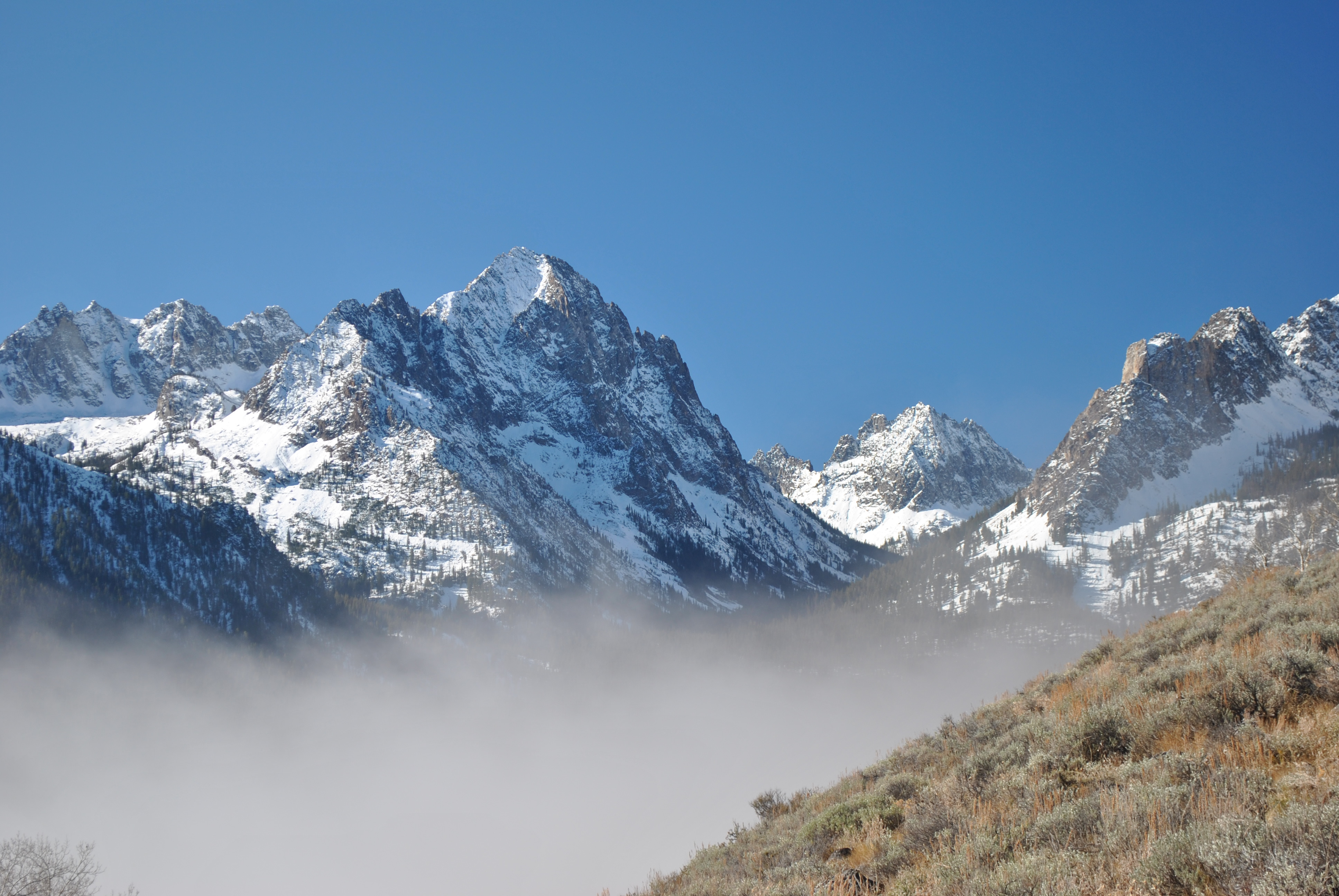
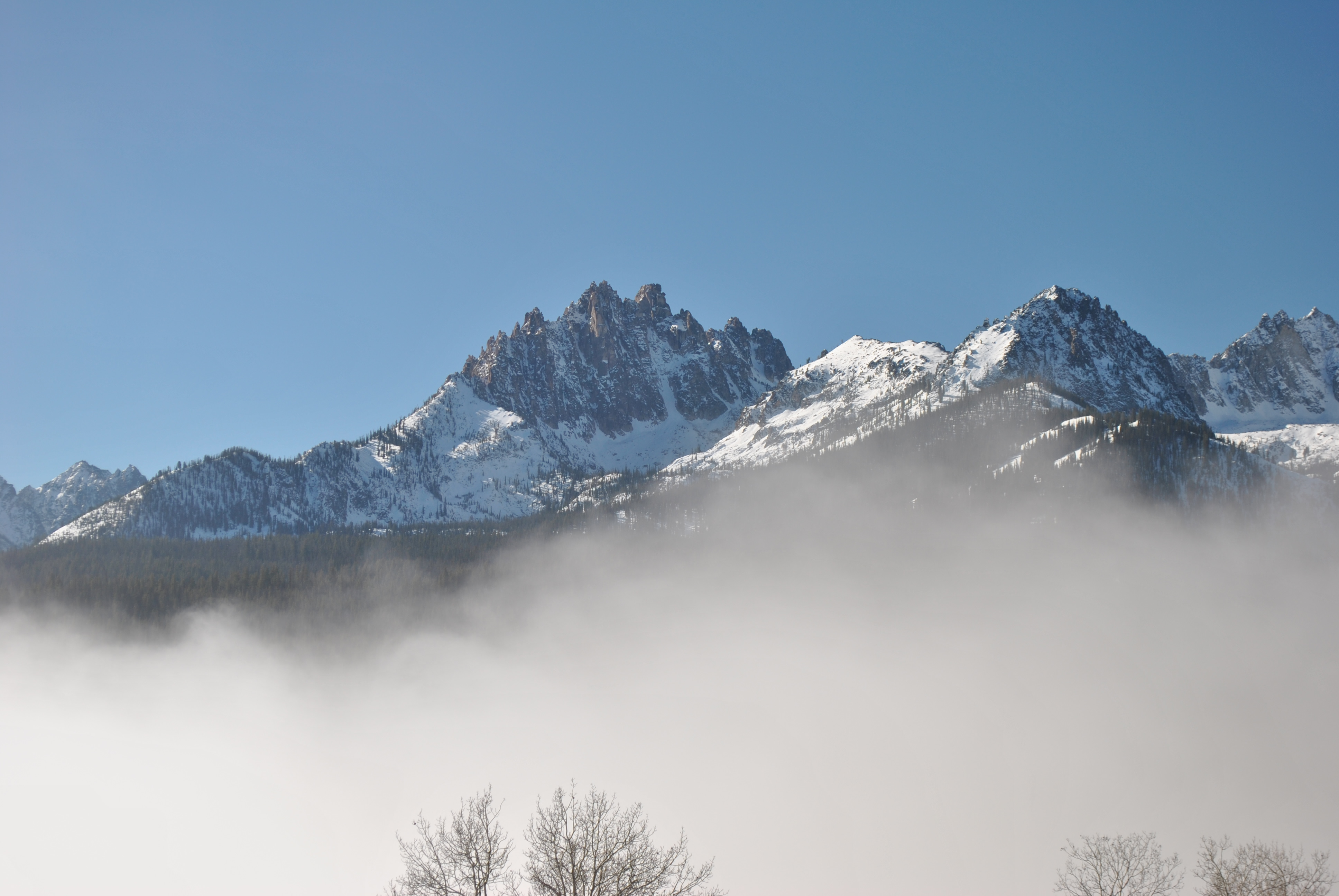
It kept me in suspense right up to the last minute. Finally near the top of the ridge I could see blue sky above but still couldn't see the mountains. It wasn't until the very top that I got high enough to clear the fog. The view was spectacular. The sky was blue and the sun was bright and warm. I could see Mt. Heyburn. It is the most prominent mountain from Redfish Lake but from here I was looking directly at the north face. Many years ago I did one of my hardest technical climbs (which wasn't that hard, actually) up the steep snow gully on the north face to the east summit. Horstman Peak dominated the Fishhook Creek drainage. It is an impressive mountain that I had tried to climb several times. It is not technically difficult but no trails go anywhere near it. I had tried to hike up trailless Fishhook Creek and not gotten very far. I tried backpacking to the highest Bench Lake and crossing over from that drainage but it was too far as well. It is still on my list to try to climb and I hope that I can do it next year. Not getting any younger.
As I was sitting on the ridge I could see the mists swirling and dissipating in the warm sun. It was quite a sight. After taking pictures of every mountain, zoom in and zoom out, every exposure bracketed, I figured that I must have some good shots that would capture the amazing view. As I hiked down the fog continued to clear. By the time I reached the trailhead it was blue sky even there. I had been gone less than two hours and the fog had pretty much cleared. I drove to a viewpoint of the lake and got some nice photos of the last of the mist clearing from the lake and the mountains.
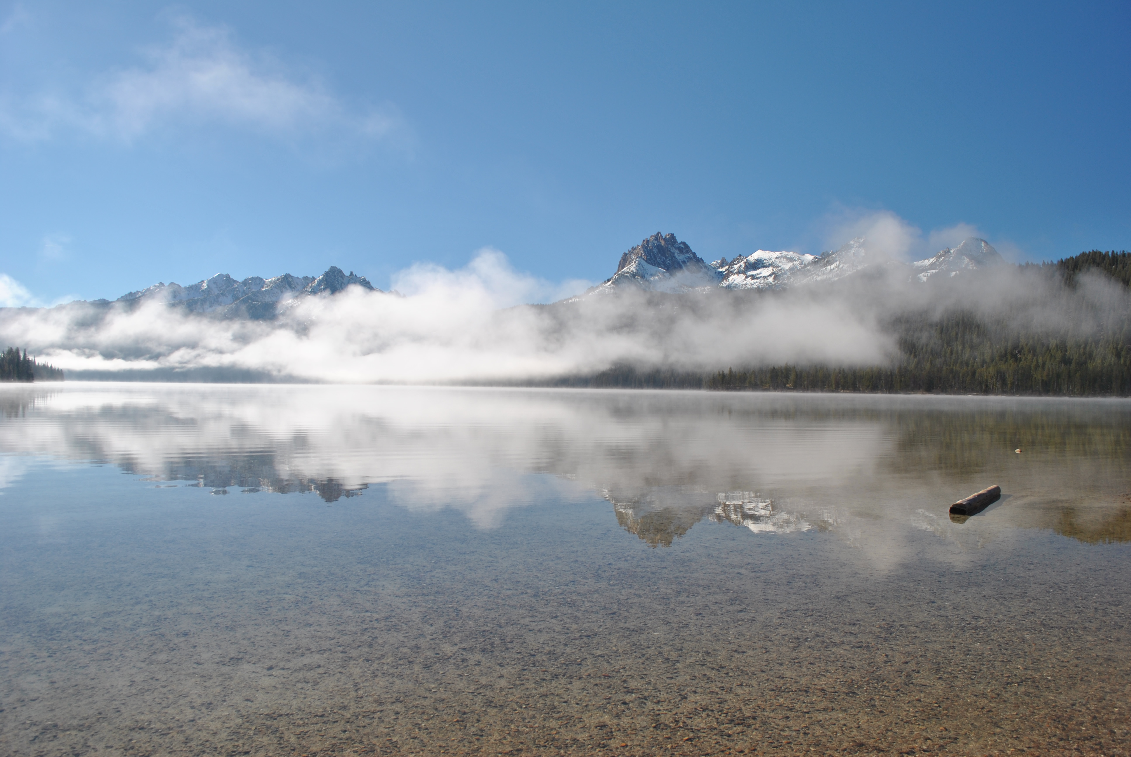
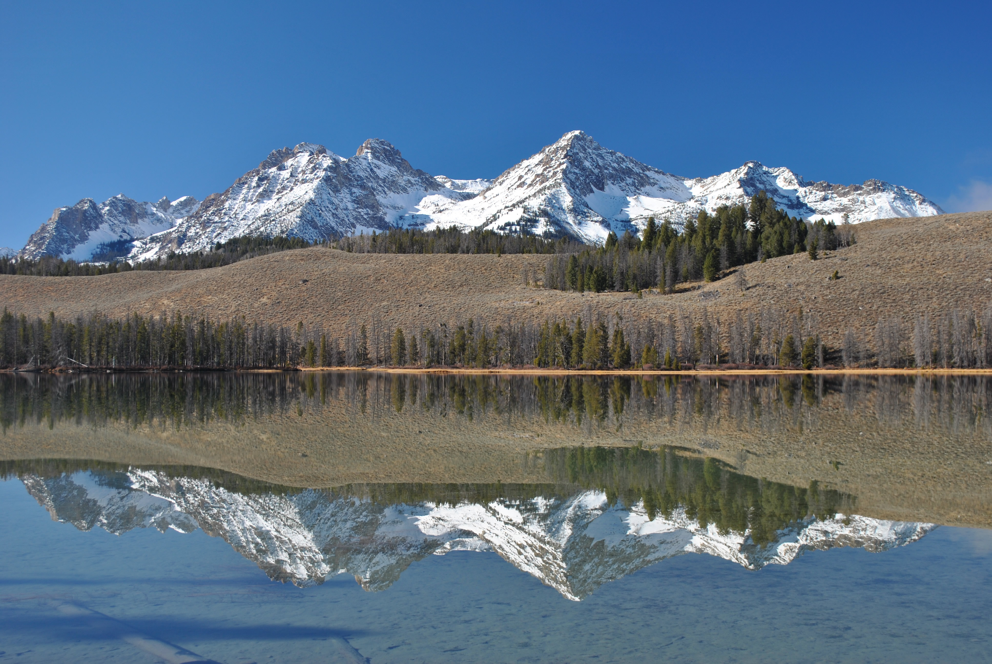 Thompson Peak and Williams Peak from Little Redfish Lake
On the way back to the highway I stopped at Little Redfish Lake. The view from there is one of my favorites and with the new snowfall it was spectacular. From there I still drove home via the southern route through Ketchum. The view all the way through the Stanley Valley was great. I did get my nice view from Galena Summit too. This late in the season the sun was in the south so the light was good even later in the afternoon. The other side of the pass has a great view of the Boulder Mountains. They have very reddish rock which provided a contrast to the bright white of the new snow.
From Ketchum it was just the standard drive back home. But it had been a great day in the mountains. I felt lucky that I had gotten another chance to go to the Sawtooths again this year when I thought the weather had turned and the season had already ended. I did get a lot of good hikes in this year but like every season, not as many as I would have liked. Rather than being tired of hiking and ready to take a break, I am always sad when the end of hiking season comes. I have lots of plans and I can't wait for next year.


