Grand Canyon: Rim To River And Back
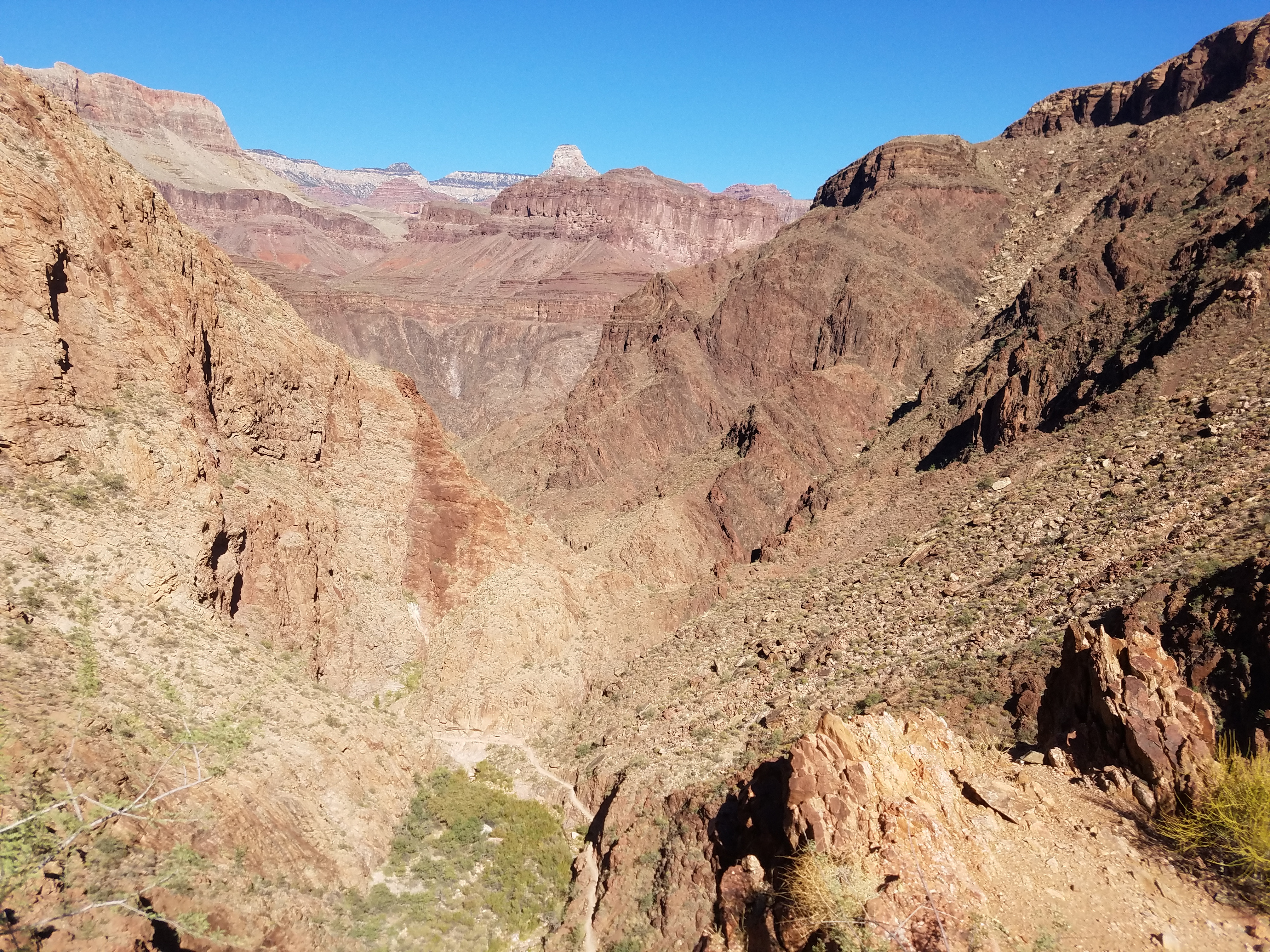
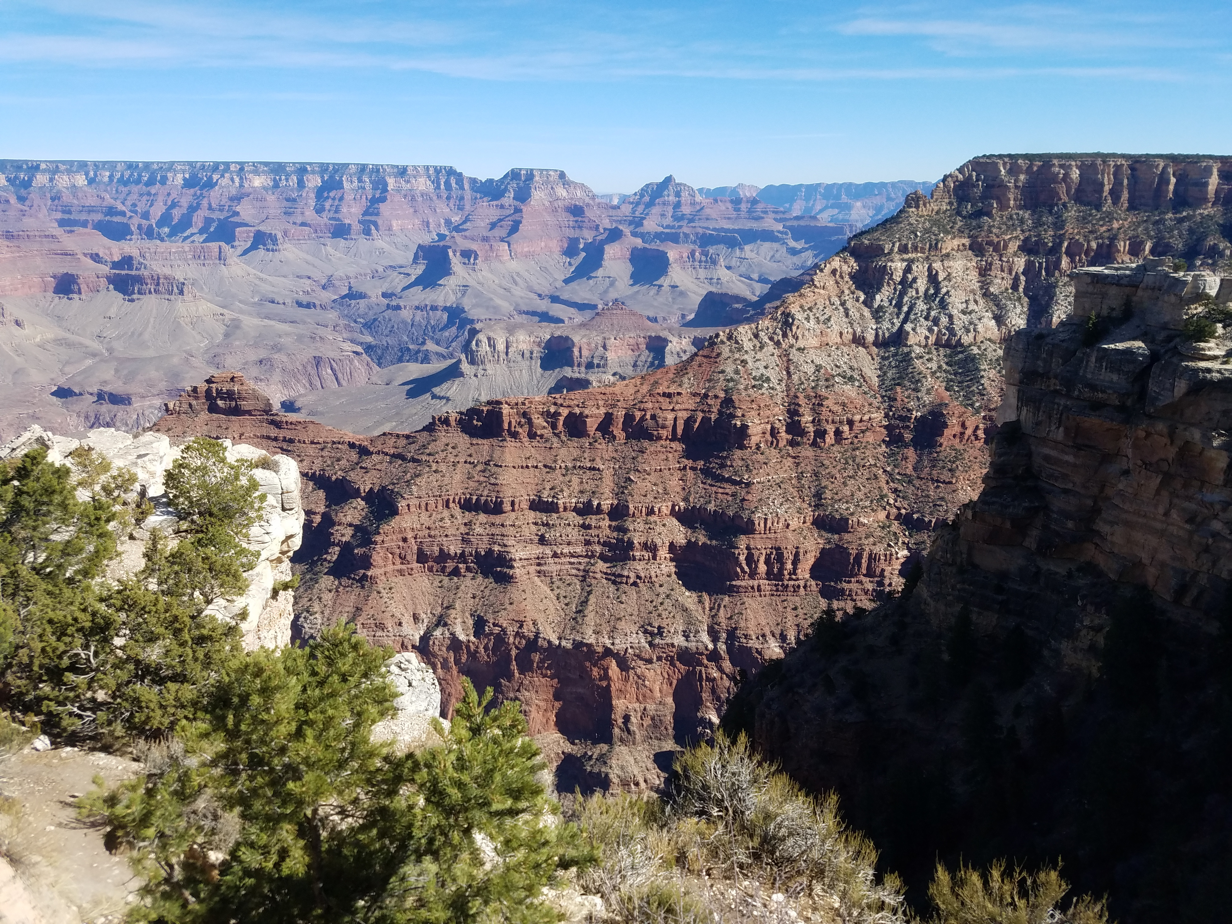 Kaibab Ridge - my route of descent into the canyon
In my opinion, the Grand Canyon isn't the prettiest canyon in the southwest. I think that Zion and others are more beautiful. But when you look at the Grand Canyon it is impossible not to be impressed by the scale. It's wide and it's deep and it's long. Being a hiker, I can't look at it without feeling a challenge - can I hike all the way down to the bottom and back up again? It's the same way I feel when I look at a big mountain and want to climb to the top.
I did hike the Grand Canyon once before. Back in the late 1980's I backpacked down and camped at Bright Angel Campground, at the bottom of the canyon, and hiked out the next day. I still remember the trip. I remember how the inner canyon felt like a different world. I remember how the climb out seemed to take forever. Looking at the canyon from the rim, it looks gigantic, but when you hike to the bottom and back, you feel how big it really is. To use an old term from my corporate management days, you internalize it.
 Gee, I wonder what trail this is?
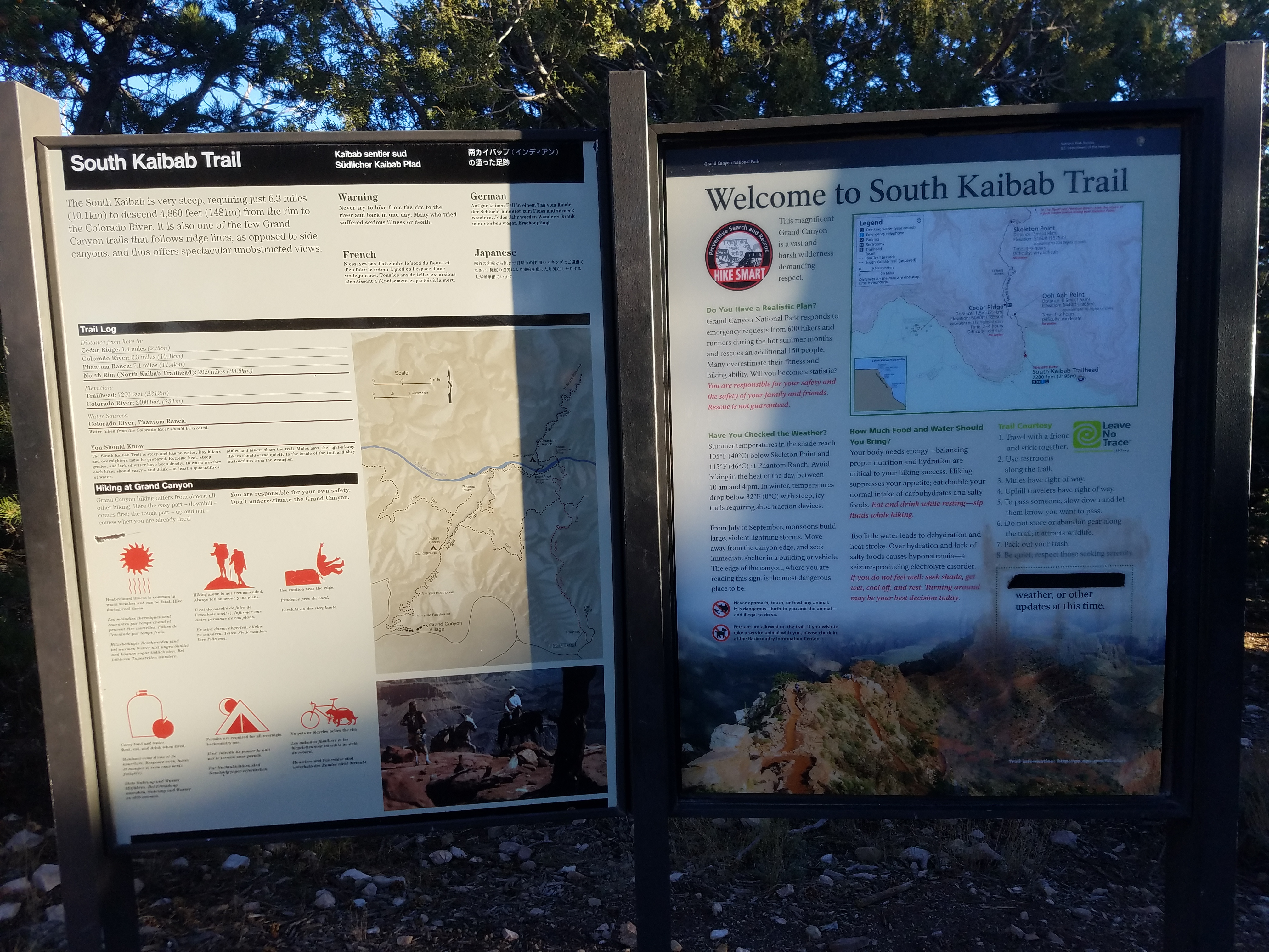
Ever since Sandy and I went to visit Grand Canyon National Park in 2013 I have been thinking of doing the canyon hike again. When I came back from my trek to Nepal this fall I thought it was the time to do it. I was in pretty good shape. The weather was good. It was the right time of year to try because in the summer it is way too hot in the inner canyon. The hike is dangerous then. Lots of hikers who try it suffer from heat exhaustion. In the winter, snow and ice can close the upper part of the trail. The rim is over 7000 feet so even in Arizona it gets snow.
Last time I did it as a backpack trip, but to do that again I would need to get a permit for Bright Angel Campground. There aren't many campsites and the demand is high, especially at this time of year, so it is hard to get a spot. I decided that I would avoid that problem by doing it as a day hike, which doesn't require a permit from the Park Service. That would make it a bigger challenge though.
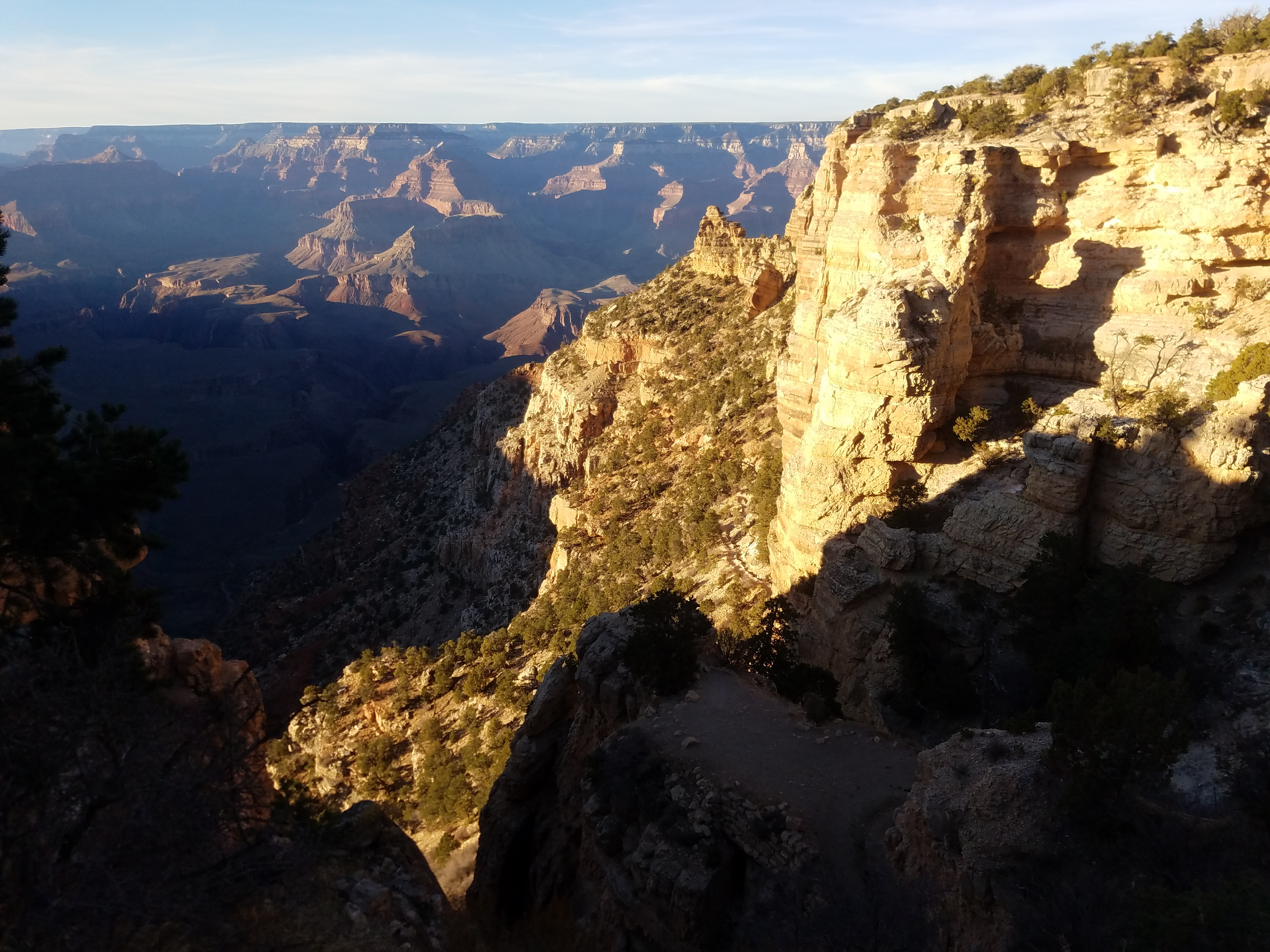 Looking down from the South Kaibab Trailhead
I talked to Sandy and she was agreeable to going. I also invited our friend Mary Beth along. She was interested since she had never been to the Grand Canyon. Sandy and Mary Beth decided that they would do a hike on the rim while I went down into the canyon.
Most people who hike from the south rim to the river and back to the south rim do it as a loop trip. They go down the South Kaibab Trail, which is the shortest (and therefore the steepest) trail down to the river. In 6.3 miles it descends 4860 feet from near Yaki Point on the south rim to the Colorado River at the Black Bridge. It's also very scenic because for much of the way it descends a ridge crest, so there are unobstructed views in all directions. That also means it has no shade - not a good choice for climbing out of the canyon on a hot day. There is a trail along the Colorado River (unsurprisingly called the River Trail) that connects in two miles to the Bright Angel Trail, which climbs back up 4430 feet to the rim in about nine miles. More gradual and with more shade, it's the choice of most hikers for the long climb out of the canyon.
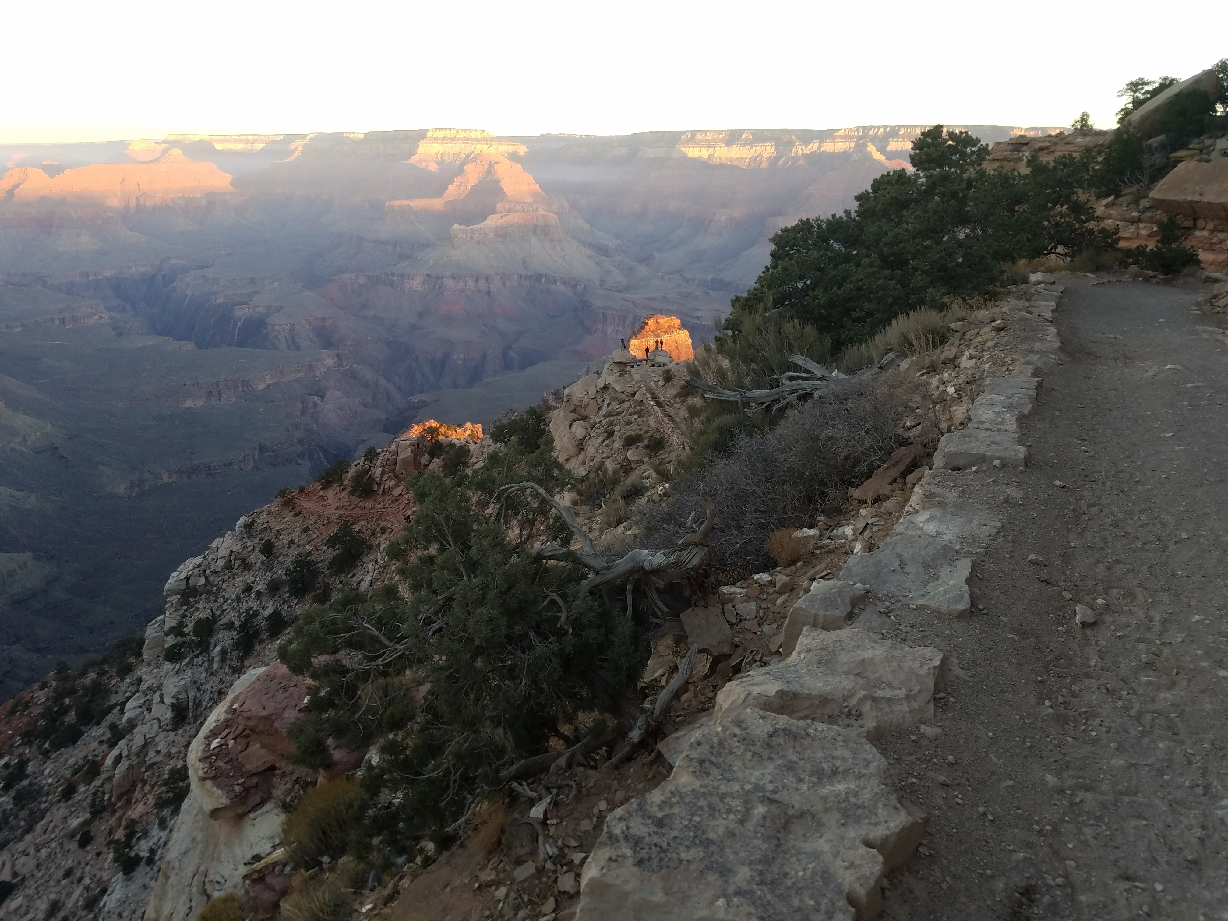 People ahead of me watch sunrise from Ooh Aah Point
I did some reconaissance for my hike the day we arrived in the park. We all went to check out the Bright Angel Trailhead where I planned to come up. It's in Grand Canyon Village right next to the Bright Angel Lodge (another surprise), about a quarter mile walk from our hotel, the Maswik Lodge.
More importantly I checked out my starting point, the South Kaibab Trailhead. Because parking is very limited there, hikers have to take a park shuttle to reach it. There is one first thing in the morning, called the Hikers' Express, that leaves from the Bright Angle Lodge. Unfortunately at the beginning of November they moved the time it started back from six in the morning to seven. That would mean it probably wouldn't get to the trailhead until 7:30, a good forty five minutes after it was light enough to start hiking. Since I had a long hike to do, and sunset was at about 5:30 pm this late in the year, I wanted to take advantage of as much daylight as I could.
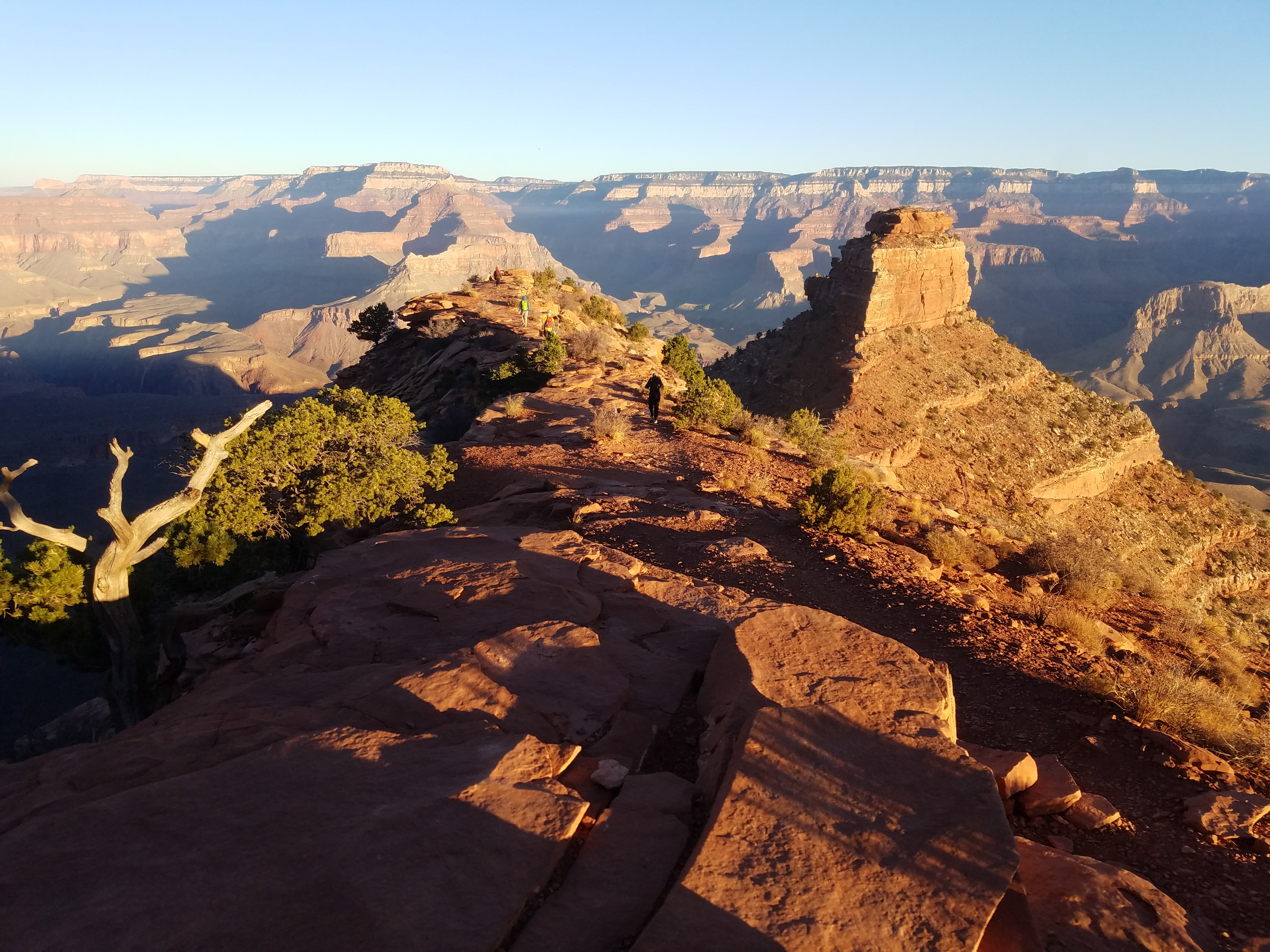 O'Neill Butte from below Cedar Ridge viewpoint
I took the rim drive to the turnoff for Yaki Point. There was a gate and a sign saying only shuttle busses were allowed on the access road. One side was open, so it might be possible to drive through, especially if I got there really early. I parked and walked from the gate to the trailhead. It was only half a mile and about a ten minute walk along the road to get to the shuttle stop. I figured I could manage that. Sandy volunteered to get up early and drive me to the gate so that I could get an early start.
That night we ate at the Pizza Pub in the Maswik Lodge. I wanted to have a good meal since I didn't plan to take much food along on my hike. We worked out our plan over dinner. We would leave at 6:15 am to drive to the trailhead where Sandy would drop me off. Sandy and Mary Beth would have breakfast when she got back and then do a hike along the Rim Trail that started at the Bright Angel Lodge. It followed the rim for eight miles to Hermit's Rest. An advantage of the hike is that the rim drive runs parallel to the trail, so when you want to head back you can just catch the shuttle. Sandy and I had hiked about six miles of the trail on our trip in 2015. Sandy and Mary Beth were determined to do the whole trail this time.
 The trail just keeps going further and further down
When we got in the car the next morning it was almost completely dark. The stars were out with just a slight brightening of the sky in the east. It was chilly - the windows of the car were covered with frost. We had to wait five minutes to let the car warm up and the windows defrost. The thermometer in the car said it was thirty degrees out. Brisk, but warmer than forecasted. I spent a long time thinking about what to wear for the start of the hike. While it was cold, I knew that it would be seventy degrees by midday at river level. I didn't want to freeze, but I didn't want to wear a lot of warm clothes starting out that I would have to carry in my pack all day, especially on the long climb out of the canyon. I had on a light fleece top base layer, a fleece vest, GoreTex shell and a warm hat and gloves. That's less than I had been wearing most mornings when I take Abby for her walk, and a lot less than I wore two weeks before in the Sawtooths. I figured it would be better to be chilly for an hour or two at the start than to have to carry a lot of extra weight. Turns out that I didn't have to worry. I had half my warm clothes off less than an hour after starting.
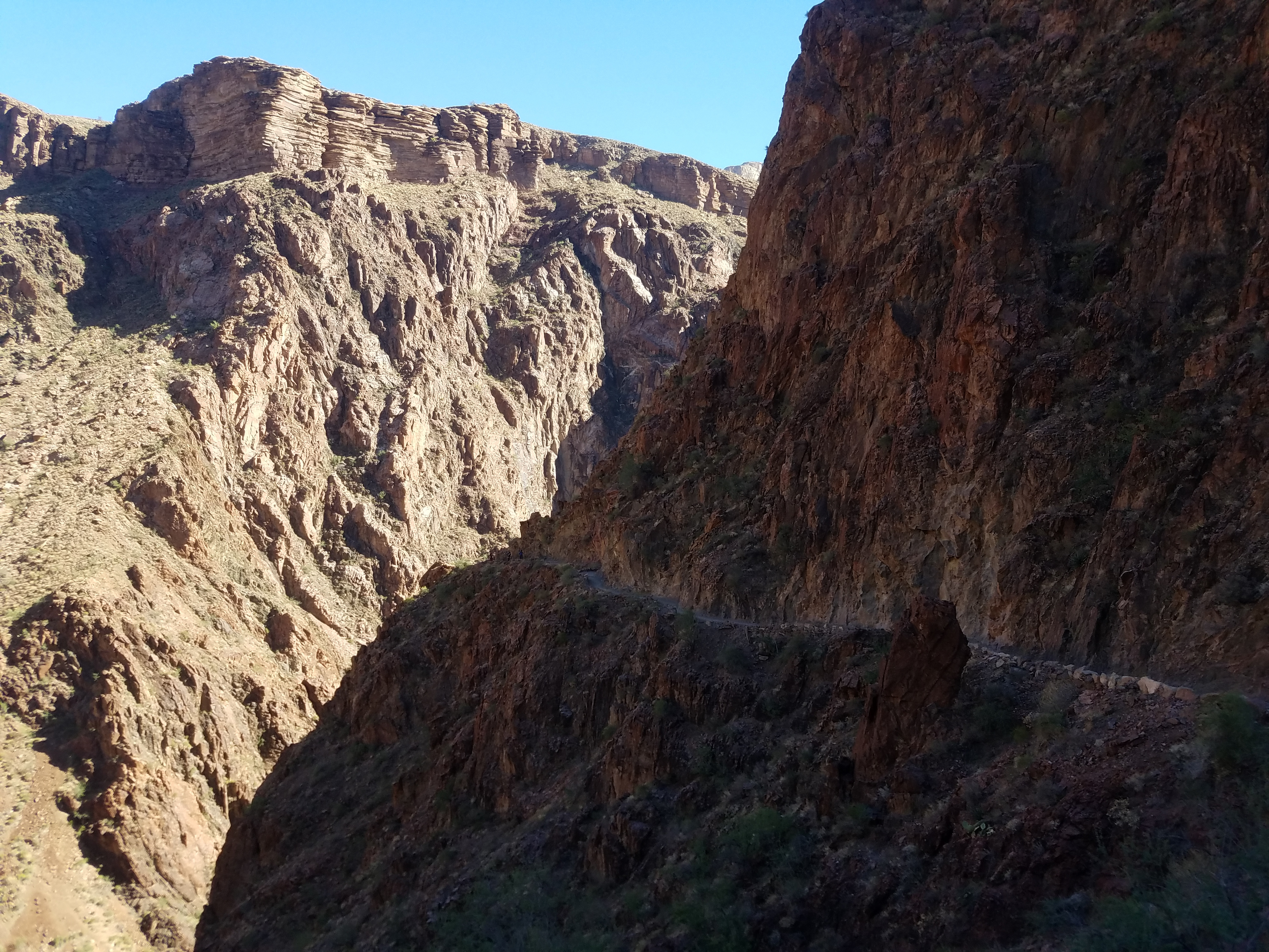
 At the Tipoff - the rim of the Inner Gorge
But I didn't know that yet. Sandy dropped me off at the gate at 6:30 am. Although I had a head lamp, by now it was light enough to see well enough to walk along the road. I reached the traihead at 6:40. I took a picture of the begining of the trail and started down. Every journey starts with the first step.
Although I thought I would have the trail all to myself this early in the morning, within five minutes I caught up to a guy walking along carrying a fancy camera and tripod. When I said hello as I passed him he asked me if this was the South Kaibab Trail. I found out that he and his fiance were having a disagreement over which trail they were on. I thought it was odd that someone could be lost five minutes from the trailhead (where there was a huge sign). I assured him that it was indeed the South Kaibab Trail. That made him happy, maybe because it meant he was in the right place, maybe because he was right and his girlfriend was wrong.
 It's still a long way down to the Black Bridge
The guy was wearing a hat with a bronco logo so I asked him if it was a Denver Broncos or BSU Broncos hat. "BSU - I just graduated from there." Small world. I told him that I was from Boise as well. He said that he and his fiance were just in the process of moving from Boise to Florida and had stopped at the Grand Canyon. It didn't exactly seem to me like it was on the way but then this guy seemed to navigate differently than I did.
Another five minutes down the trail I heard a noise and looked around. A mule train was coming down right behind us, probably carrying supplies to Phantom Ranch, a rustic lodge at the bottom of the canyon. Wow. I was expecting to have the trail all to myself because of my early start. Not so. I also was not crazy about having to deal with pack trains on trails with steep dropoffs, especially after my trip to Nepal. On my trek it seemed that on some days I encountered a group of donkeys (or horses or yaks) on the trail every fifteen minutes. Fortunately this group turned out to be the only mules that I saw on the trail today.
 I finally made it down to the river
When I reached Ooh Aah Point, the first major viewpoint along the trail, there were already six or eight people there with cameras set up for the sunrise. I guess I hadn't gotten such an early start after all. There had been a number of cars parked near the turnoff for Yaki Point. Now I knew why. While they were taking lots of pictures of the sunrise I just stopped long enough to snap a couple of quick shots and then kept going.
It wasn't long before another group of four hikers caught up to me from behind. I heard them talking among themselves in a foreign language. I thought that it sounded like Russian but I wasn't sure. I was curious what it was so when they passed me I asked one of them where they were from. "New York" he said. Ok, that wouldn't have been my first guess.
He asked me where I was from and when I told him Boise he said "Idaho is one of the most underrated states. I love Idaho! I love the Sawtooth Mountains. I've been to Stanley many times." Small world again. I figured that today must be Idaho Day on the South Kaibab Trail.
 Looking back after crossing the Black Bridge
Shortly after they passed me (because I'm slow and everyone passes me) I reached the Cedar Ridge viewpoint. Enjoying the view as I walked, I followed the four hikers ahead of me along the ridgecrest for a few hundred yards. Then I noticed that the trail seemed pretty sketchy. Not something I would expect. I could see the trail far below and following it back up towards me I noticed that it ran along the east side of the ridge, about a hundred feet away. That's what I get for blindly following other hikers. Fortunately there was a light track that cut across to the trail so two minutes later I was back on track.
The trail just kept heading downward. It was a beautiful morning and the view was magnificent. The only thing that kept the hiking from being perfect was the nagging thought in the back of my mind that I eventually had to regain all this elevation that I was losing. I knew that it was going to be a long grind going back up.
 Silver Bridge with the Black Bridge in the distance
I was by myself most of the time. The only other people that I saw on this stretch were two solo joggers, who passed me at different times on their way down. Surprisingly they weren't young guys but looked to be in their fifties. Here I thought that I was doing well just to walk down to the river and back, much less run.
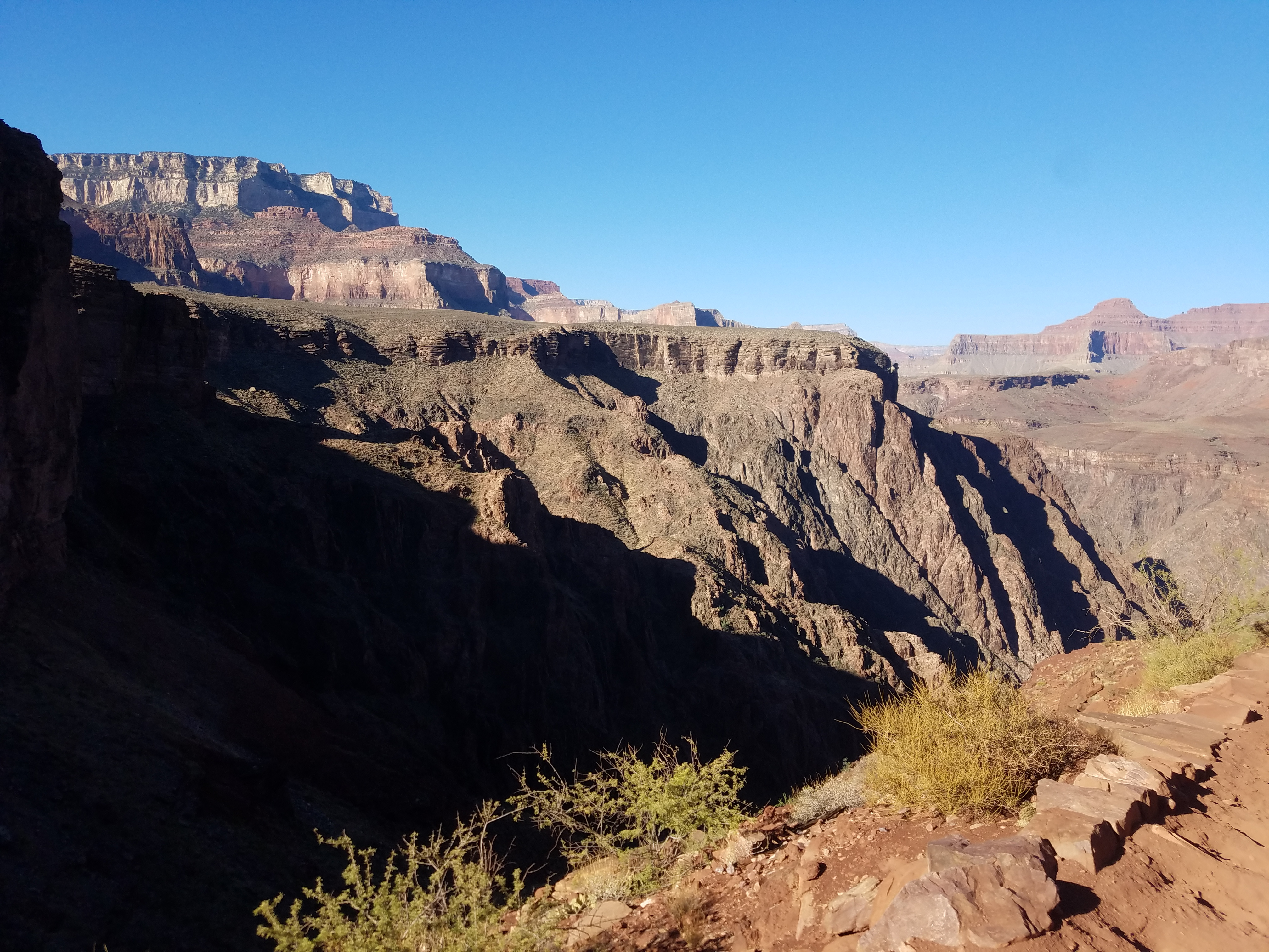
Eventually I reached the Tonto Plateau, a large flat area leading to the rim of the inner canyon. Now I started to encounter a few backpackers climbing up after spending the night at the bottom of the canyon. Although it would be nice to break up the trip into two days, I didn't envy them hiking out carrying heavy backpacks with full camping gear.
As I was getting close to the edge of the Tonto Plateau I was passed by a large group of young people who were moving fast. At the Tip Off, where the trail went over the edge to descend into the inner canyon, there was a fancy, high tech, solar-powered two-story compost toilet. The whole group stopped there and lined up for the bathroom so I went past them again. It would turn out that we would be leap-frogging each other all day.
 Mom and the kids out for a walk in the park
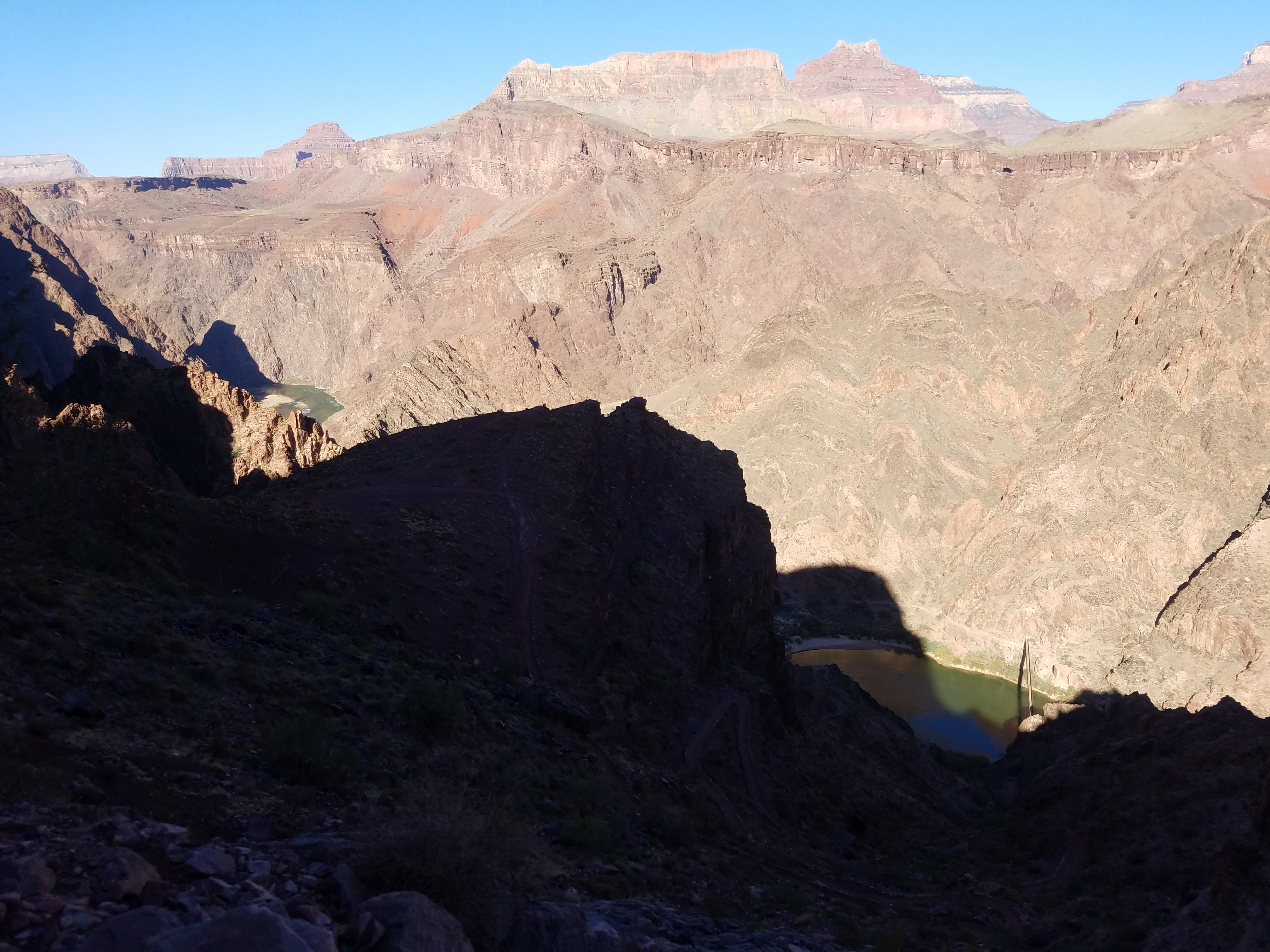
When I reached the Tip Off and looked down into the inner canyon I could finally see the Colorado River and the Black Bridge far below. It was like reaching a false summit while climbing a mountain. A false summit is a high point that from below looks like the top, but when you reach it you see that you still have a long way to go. It's usually very discouraging even when you know it's a false summit. Somehow the top is always farther away than you imagined it would be. The Tip Off was the same. I knew that the river was still a long way below but I couldn't help groaning when I saw how far away it actually was. There was nothing to do but keep going down.
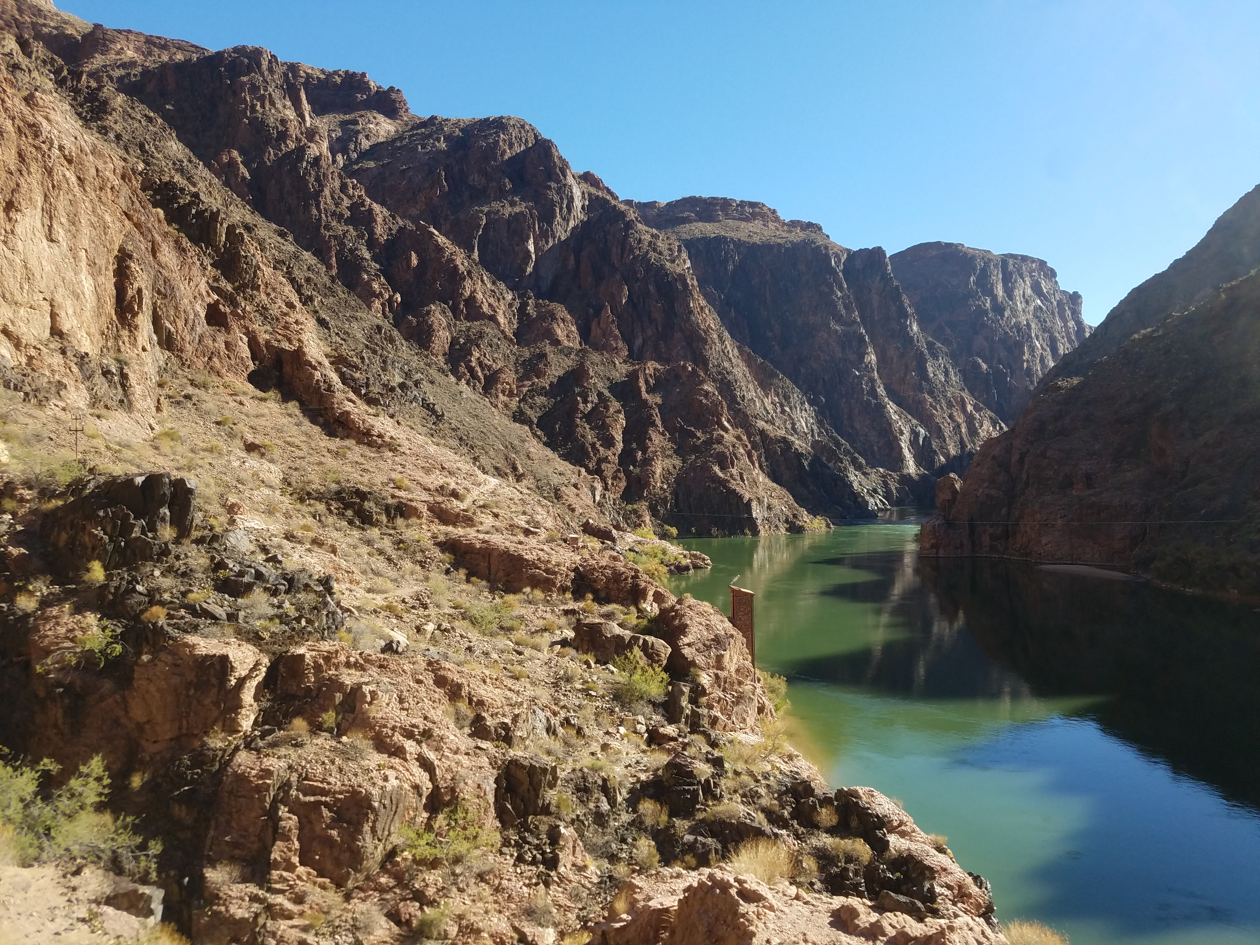
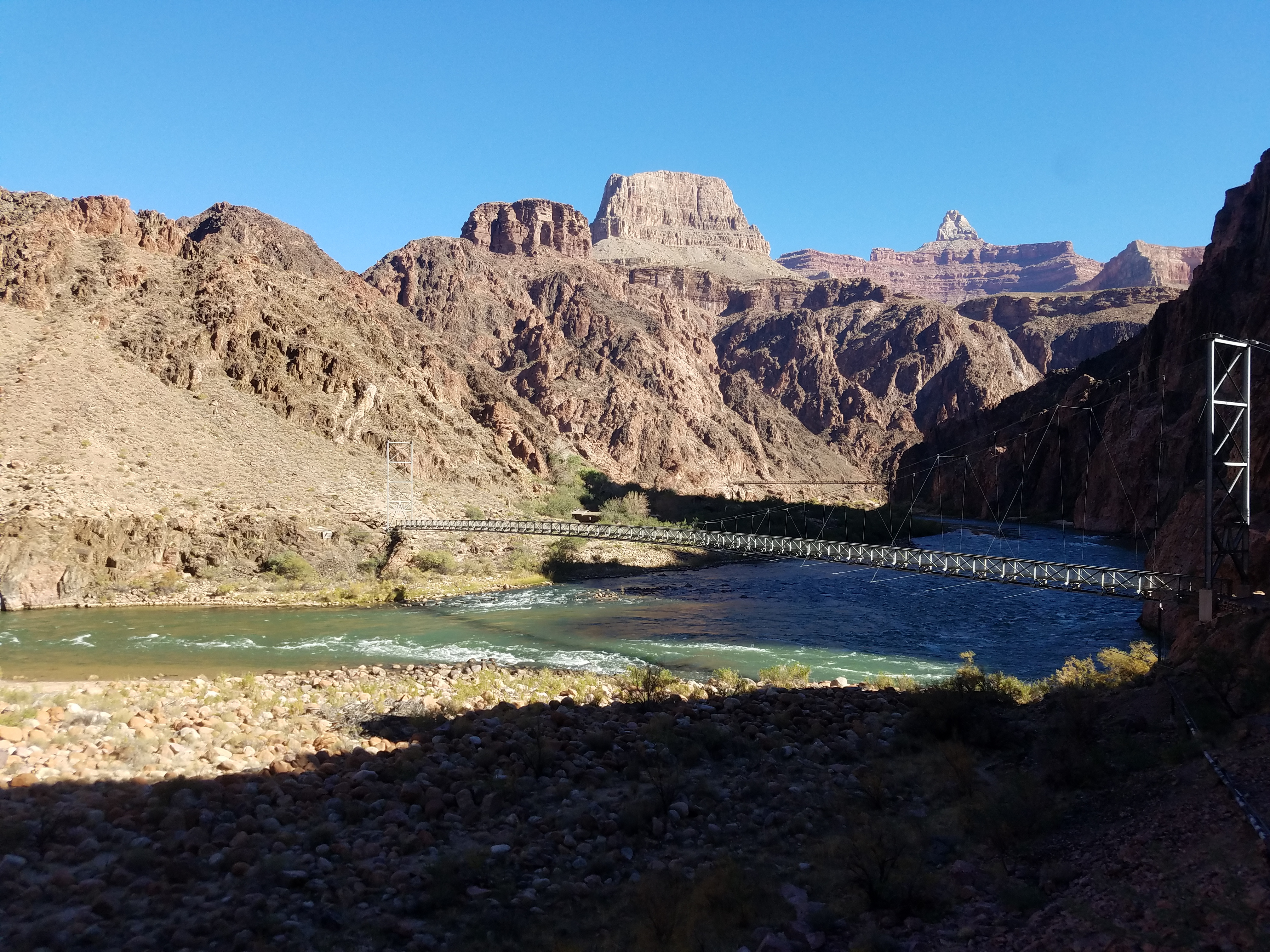
Finally I was getting close to the bottom. I reached a junction with the River Trail, which follows the south side of the river to the Bright Angel Trail. That's where I planned to go but instead of staying on this side of the river I wanted to cross over the two bridges that span the Colorado and take the trail on the opposite bank.
The first crossing is over the Black Bridge, named that because...it's black. It's in an unlikely spot. It's high above the river and on the south side it ends in the middle of a cliff. To reach it you have to walk about a hundred yards through a tunnel that is blasted out of the rock. It's quite an experience to step out of the pitch dark tunnel into the bright sunlight and find yourself standing on a narrow bridge sixty five feet above the water. It does have a wooden plank floor so at least you aren't looking straight down between your feet to the river. Because of the solid floor it's the only bridge that the pack mules will cross. The Silver Bridge, 700 meters downstream, has see-through metal grating which mules refuse to cross.
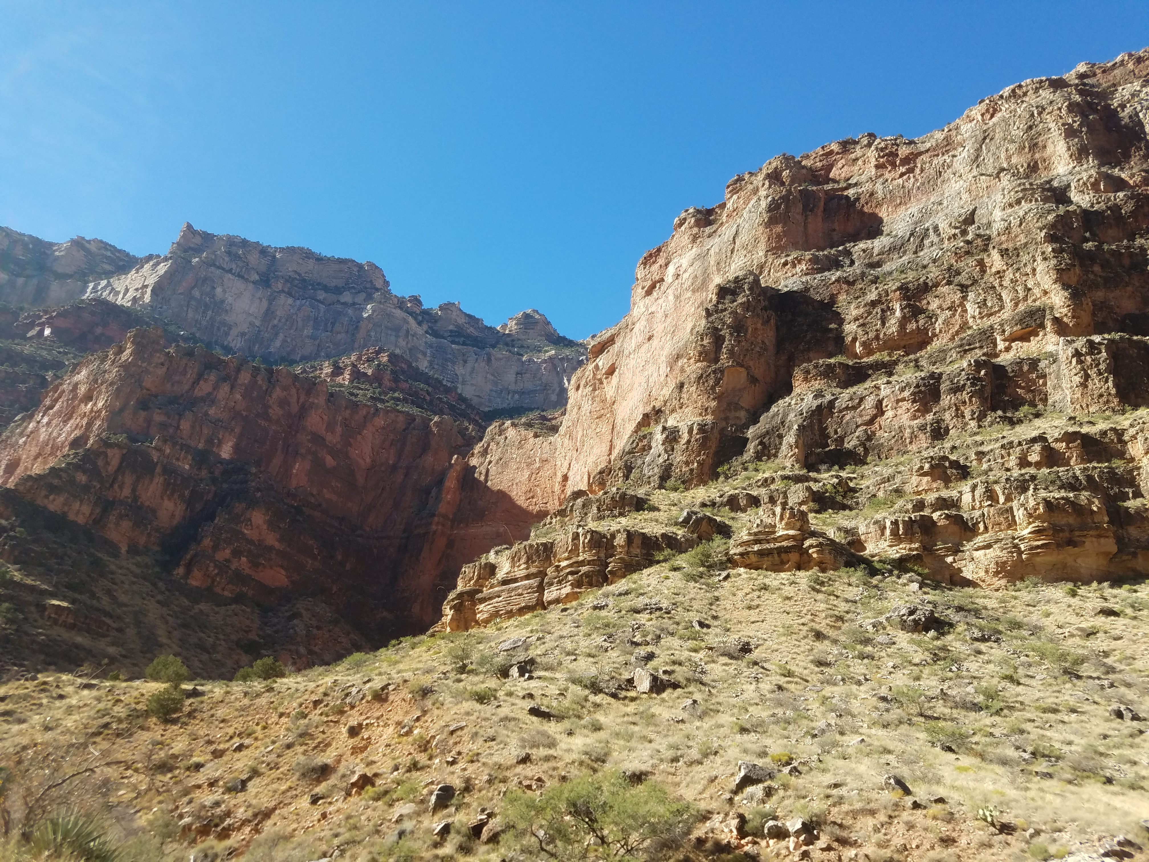
 Inner gorge - the rest of the canyon isn't even visible
I was glad to be down to the river. I had covered a little over six miles and since it was downhill I expected to be able to make good time. I had left the trailhead at 6:40 am and it was already 10:15 am. Three and a half hours to come down meant that I was behind schedule. I still had to cover two miles along the river and then do the long climb back to the rim. Since sunset was at five thirty and it was dark by six, I had to make good time uphill if I didn't want to be finishing the hike using my headlamp in the dark.
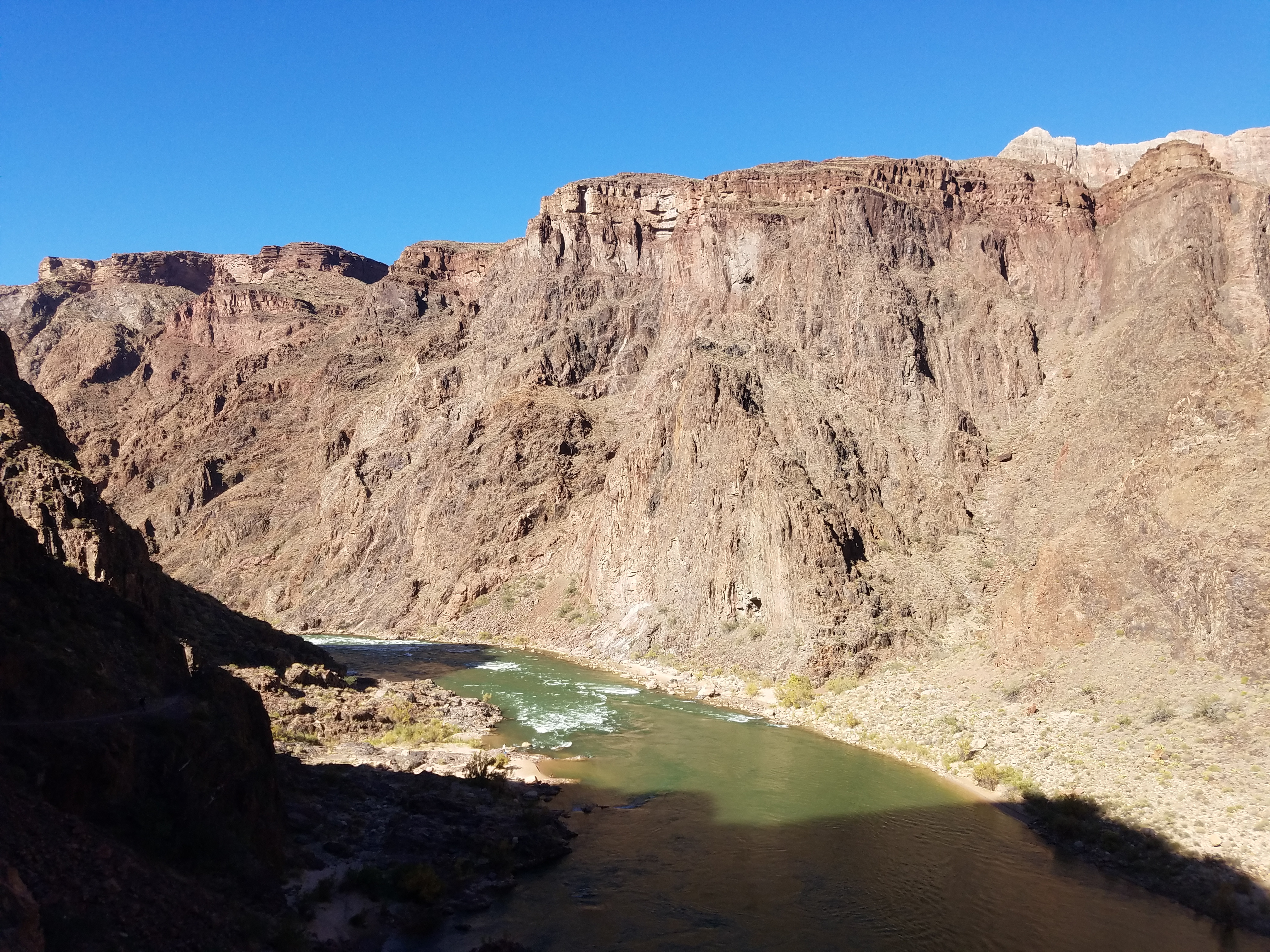
That didn't stop me from enjoying being at the bottom of the canyon. It's an amazing place. The inner canyon is about two thousand feet deep and quite steep. Just as you can't usually see the river when you are up on the rim, from the river you can't see any of the upper portion of the canyon. The inner canyon is pretty much its own world. While you are there you always know in the back of your mind that it is very remote, that you have a long way to go to get home and that you can't stay for very long. Like being on the summit of a mountain, your time here is short and very precious.
 My rest stop beside a small but pretty cascade
Once I crossed the Black Bridge it was just a short walk to a trail junction. The right fork was the start (or end, depending on which way you are going) of the North Kaibab Trail, which goes to Phantom Ranch, a small, rustic lodge which is the only accomadation anywhere inside of the Grand Canyon. From there the trail continues up Bright Angel Creek another fourteen miles to the north rim, climbing a total of 5850 feet from the Colorado River.
I would love to do that hike someday, going from one rim down to the river and then up to the other rim. It would require arranging a car shuttle. I'd have to talk Sandy into driving around from one side of the canyon to the other to meet me, a distance of about 180 miles by road. Either that or I'd have to hike it both directions. People who do that usually stay overnight on the opposite rim. That means hiking down to the bottom of the canyon and then out again two days in a row. I'm not sure I'm crazy enough to do that so I'll have to keep working on Sandy to be my shuttle driver.
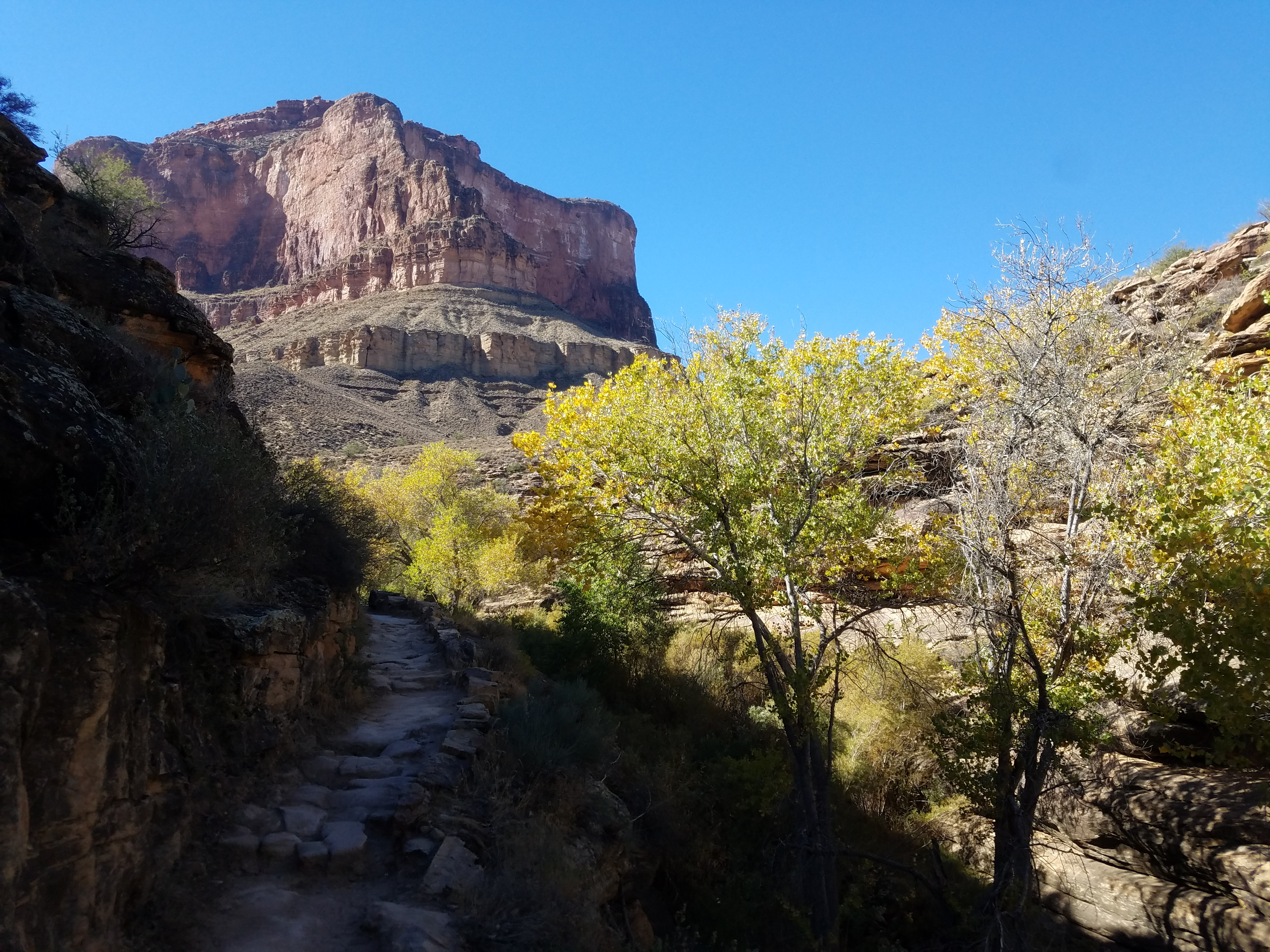
 Looking down on the trail along Pipe Creek
To the left of the trail junction were a small number of campsites for backpackers known as Bright Angel Campground. I had stayed there overnight on my previous hike into the canyon thirty years ago. There was a toilet and a faucet where you could get drinking water. I had to go over to check the water. According to the Park Service website it was supposed to be running but I hadn't been sure that I would be able to find it when I reached the bottom of the canyon.
Even though I wanted to keep my pack as light as possible, I had carried two and a half liters of water. I didn't want the weight but running out of water would be worse. Now it turned out that the drinking water in the campground was indeed running and I had found it easily. So far I had taken about five sips from the water that I was carrying. Needless to say I was irritated. It would have been better if I hadn't seen that I could get water here. Oh well. Better safe than sorry.
 Trail out of the inner gorge trail - at least it's in the shade
A short distance beyond the campground was the Silver Bridge, which I crossed to get back to the south side of the river. The primary reason that the bridge was built was to provide a support structure for a water pipe that runs from one side of the canyon to the other. All of the water that is used on the south rim (ie. in Grand Canyon Village) comes from Roaring Springs near the north rim. It's piped under natural high pressure down Bright Angel Creek to the bottom of the canyon, across the Colorado River on the Silver Bridge, and then up along Pipe Creek (hence the name) to Indian Gardens. From there a pumping station sends it the rest of the way up to the south rim. About half a million gallons of water flow through the system every day. The pipes are old and fail several times each season, so there are large storage tanks on the south rim to keep tourists and park employees supplied with water while repairs are made.
 I'm in the desert and I'm hiking up a stream
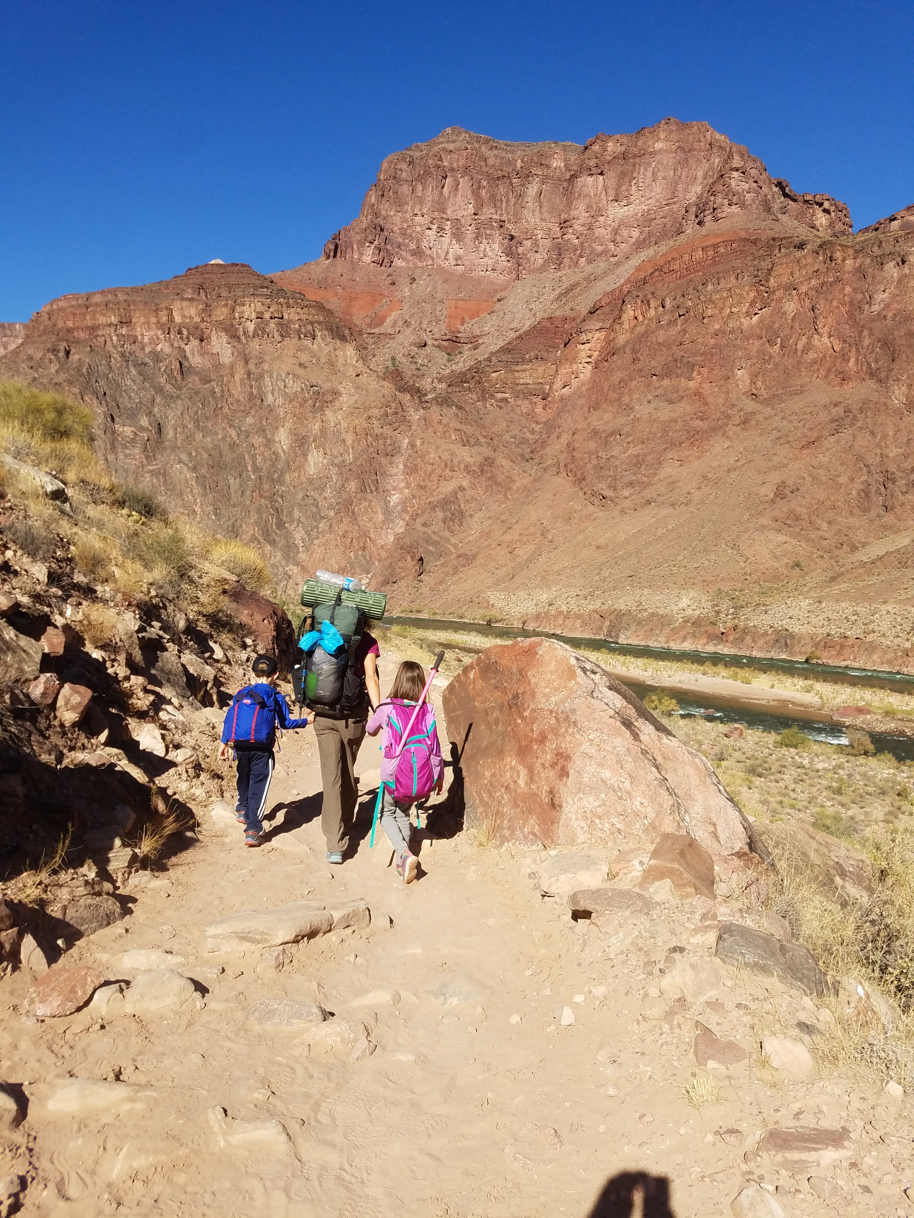
Just across the bridge I was surprised to see a woman hiking with two young kids. She had a full backpack and each of the kids had day packs. Wherever they were headed they had a long way to go to get there. I chatted for a bit when I passed them (yes, they were even slower than me). The kids were talkative so I asked how old they were. The girl said that she was eight and that her brother was six. She also volunteered that her mom was forty five which got her a dirty look from mom. (I said she was talkative.) I certainly wouldn't be brave enough or tough enough to go backpacking to such a remote spot with small children.
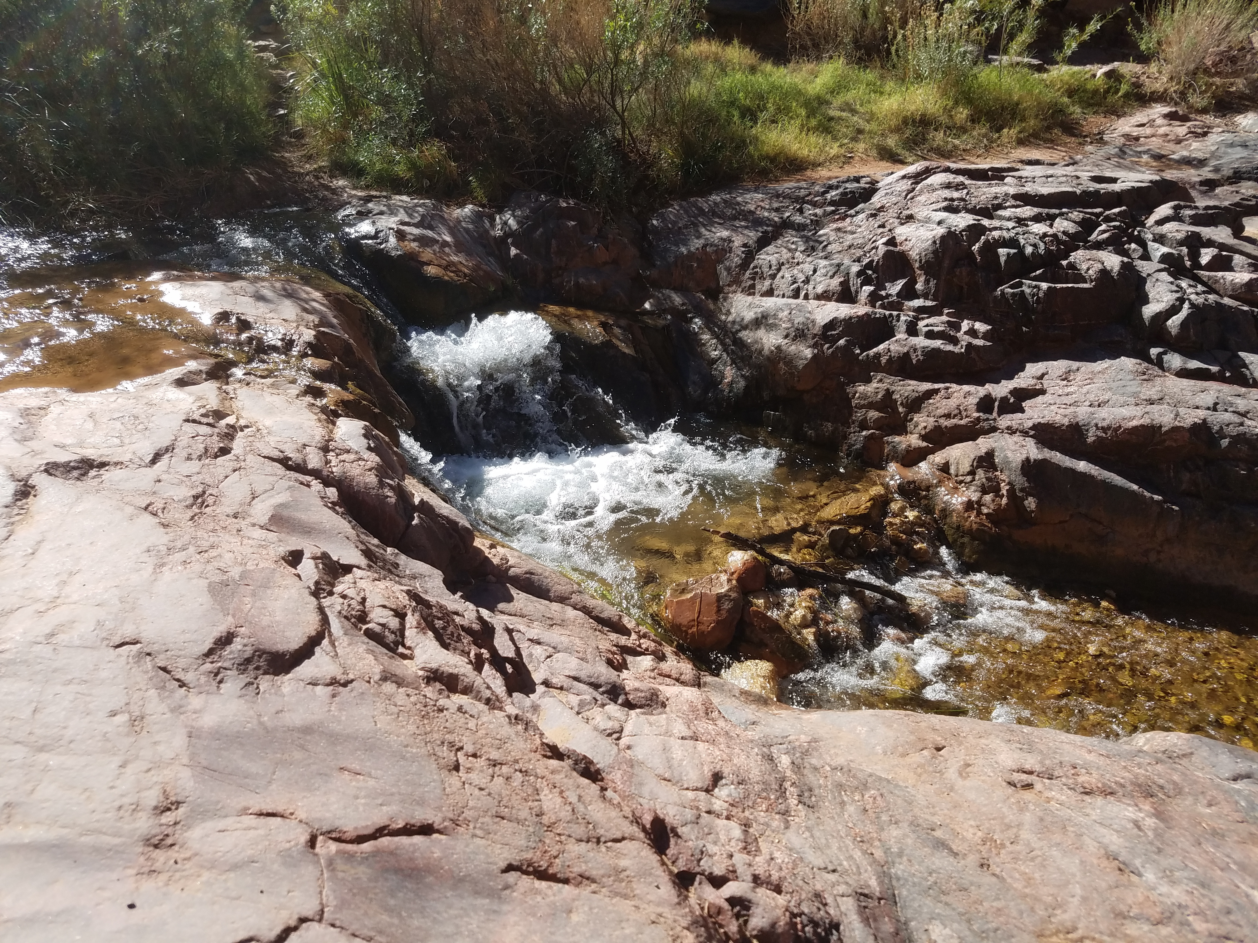
The trail followed the Colorado River for 1.8 miles to Pipe Creek Beach, where there was a hikers shelter. Here the trail turned away from the river and headed up Pipe Creek, becoming the Bright Angel Trail and leading back up to the south rim. Near the shelter there was a small cascade and since I hadn't taken a break yet all day, I stopped beside the creek for a rest before starting up and out of the canyon. When mom and the kids arrived at the shelter they were greeted by other hikers who were waiting there. It looked like they were stopping and planning to stay overnight. They must have been doing the trip over many days.
After my break I started the climb back up to the rim. It was 11:15 and I figured I had six, maybe six and a half hours of daylight to gain 4500 feet. Given my progress so far, at this point I was thinking that I would be finishing the hike in the dark. I had my headlamp so that wouldn't be a problem but I would be disappointed it took me that long to finish.
 Coming out of the inner gorge - a lot more climbing left
Pipe Creek is a major weakness cutting through the sheer walls of the Inner Canyon. The trail up it was pleasant and climbed at a reasonable grade. It was different than the hike had been so far. On the way down I followed the crest of a ridge with the immensity of the Grand Canyon all around me. Now I was hiking up a small canyon, deep and steep with nothing visible beyond it's narrow walls. There was a small stream, very pretty, descending in a series of rocky, bubbling cascades. The canyon was green and lush, at least by comparison to the dusty desert I had been hiking through all day.
Eventually I reached the head of Pipe Creek and the trail started to switchback up a steep wall, a section known as the Devil's Corkscrew. During the summer this section can get to 130 degrees without any shelter from the sun. Today it was pleasant, more like sixty degrees. Still, it was steep enough that pretty soon I was sweating as I climbed.
 At Indian Garden - now they tell me
As I got higher I could look down Pipe Creek, back towards the Colorado River and the inner canyon walls rising on the other side. I could see that I was getting close to the lip of the inner canyon and I expected to top out on the rim, onto the large flat area known as the Tonto Plateau. Instead the trail stayed in a narrow, shallow gully along the creek. In fact for a stretch the creek flowed over the trail and I was rock hopping for about a hundred yards to stay out of the water. Not exactly what I expected in the desert.
At one point I passed a group of about ten backpackers who had stopped by a grove of trees next to the stream. One guy was laying out food on a big tarp. He must have been a guide and he was leading a commercial group. It seemed like a pretty easy trip to have to pay a lot of money so you could be herded along, but I guess at least those guys were out there hiking instead of watching tv.
 Looking up at the route above Indian Garden
I finally reached Indian Garden, the midpoint between the river and rim where there is a campground for backpackers. It's possible to make the hike that I was doing a three day trip. You can camp one night at the Bright Angel campground at the bottom of the canyon and another night here at Indian Garden, splitting the hike out into two days. It was a very pleasant spot and it would definitely make it a more relaxed trip. I finally stopped and spent twenty minutes in the shade under some trees, eating my lunch and drinking the Diet Coke that I had carried all day.
When I finished and was ready to go again it was 1:15 in the afternoon. I only had 4.5 trail miles but almost 3000 feet of elevation to go. It broke up into three equal sections. A mile and a half and one thousand feet up was Three Mile Resthouse. Another mile and a half and another thousand feet higher was Mile and a Half Resthouse. Then there was the last mile and a half and thousand feet to the rim.
 Sandy meets me near the end of the trail
As I was going uphill I was leapfrogging with a group of about ten hikers. They were all young, roughly college age. They would zoom past me going uphill. Then some time later I would pass them as they sat by the trail, talking among themselves. We did this at least a half a dozen times. One of them had a tshirt that had "First year DOG trips" and a list of places written on the back. I had to admit that I was curious about it. When I passed him at one of the stops I asked him about the tshirt. What were the DOG trips about? It turned out that I had misread it. He said "No, it says DOC - Dartmouth Outing Club". Oh. Turns out they were a group of students from Dartmouth College. The were all taking a geology class and kept stopping to inspect the various rock layers. That explained why I kept catching up to them.
Personally I think a "DOG trip" tshirt would have been much cooler.
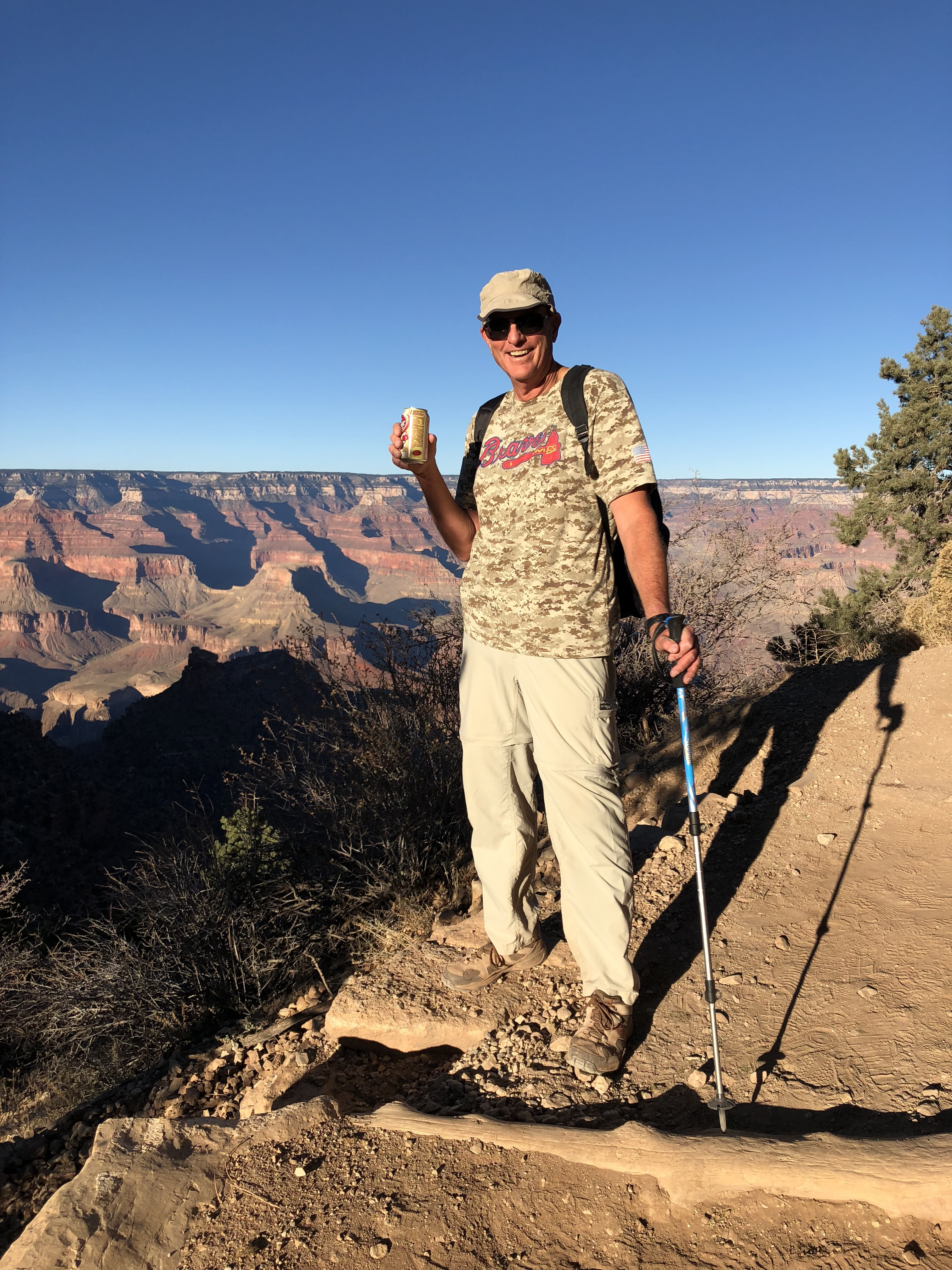
I was finally out of the inner gorge and could see the whole Grand Canyon. It was intimidating. Looking across to the other side of the canyon I could see the level that I was at and how far it was below the rim. I had a long way to go. But I felt really good and just kept going at a slow but steady pace. In just an hour I was at Three Mile Resthouse. When I checked my phone I finally had signal, so I sent Sandy a text saying I was on my way and getting close. Another hour and I was at Mile and a Half Resthouse. Now I could actually see the rim above me, although it still seemed a long way off. I just kept going. Finally I was almost there. I reached the second tunnel, cut through through a cliff, that is only ten minutes from the top. Sandy was waiting for me there. She had come down to meet me and she brought a cold Dr. Pepper. She scored a lot of Wife Points!
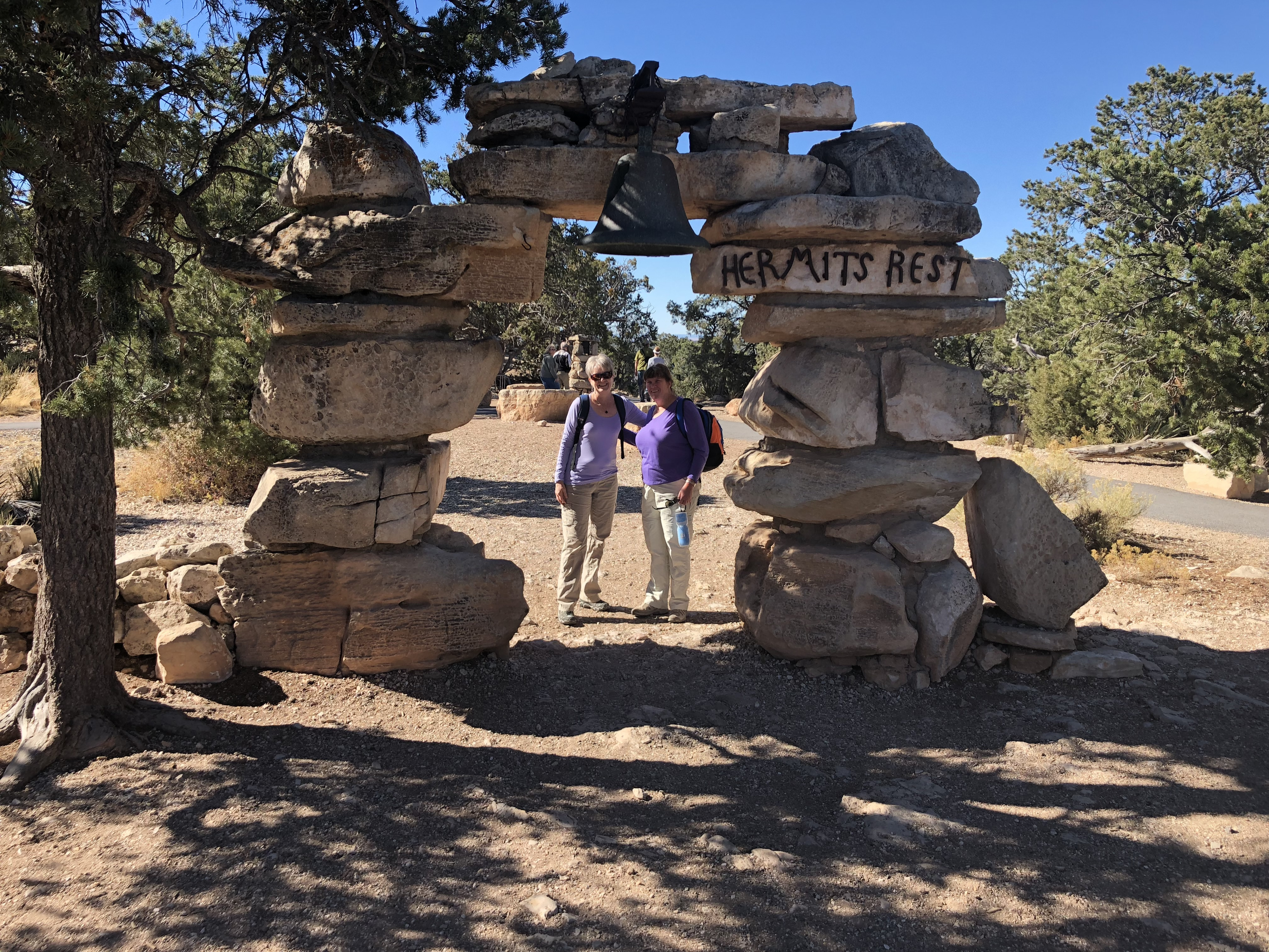 Sandy and Mary Beth hiked the Rim Trail to Hermit's Rest
Finally I was at the top. It was 4:15. It took me nine hours and forty five minutes from when Sandy dropped me off. Not a fast time but I felt really good. I was moving well even at the end. I could have gone farther. It was an amazing hike and I was pleased to have done it in a day.
Sandy and Mary Beth did well too. They had hiked all eight miles to the end of the rim trail at Hermit's Rest. So we all had cause to celebrate. After cleaning up, we went to the Bright Angel Lodge for dinner and a good bottle of wine.
Life was good.
