Climbing Half Dome
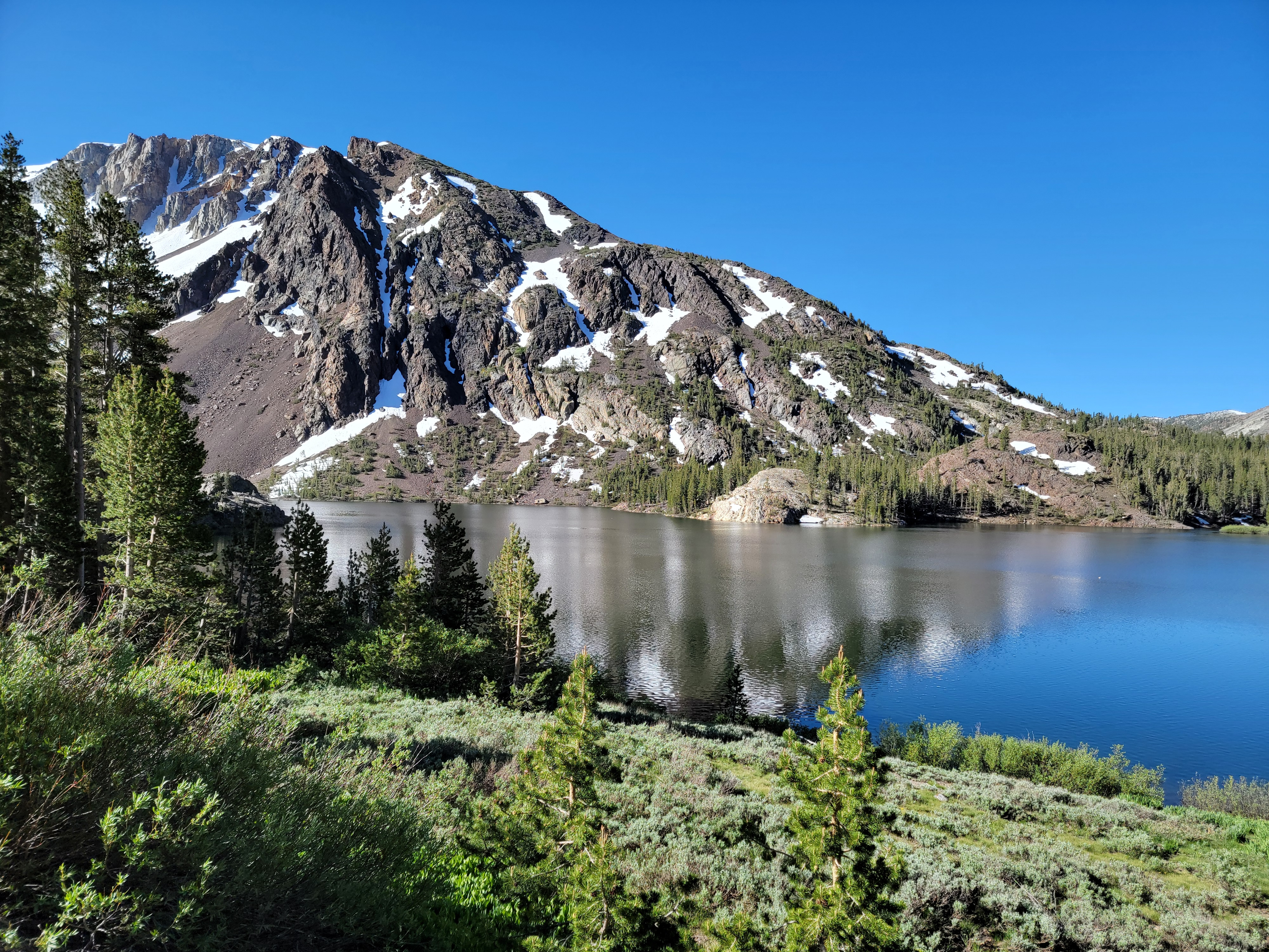 Tioga Lake - on the road to Yosemite NP
NOTE: This is the longest post I have ever done for the Dog Blog.
TLDR: It was really hard. I did it. I'm very proud of myself.
I've always wanted to do North Coyote Buttes, a famous hike in Northern Arizona. It's more popularly known as The Wave. If you think it's strange to start a post about climbing Half Dome with a discussion of hiking in Arizona, I understand. Bear with me for a bit.
Every year I go to a wargaming convention, ConsimWorld Expo, in Phoenix. Well, at least I try to go every year. It's a long drive and I often break it up by stopping and doing a hike somewhere in Southern Utah or Nevada. This year I thought, why not do The Wave when I drive down to CSWE? Yeah, June would not be the best time of year to do it, but as long as I was passing by, it seemed like a good opportunity. But there is more to it than that. Because the area is very sensitive, the BLM strictly limits the number of visitors who can hike to The Wave. A permit is required and only 64 hikers a day are granted one. There is an online lottery to get a permit. Some are given out several months in advance. Some are held back and given out the day before. With as much interest as there is, it's pretty hard to get a permit. I thought I would at least try.
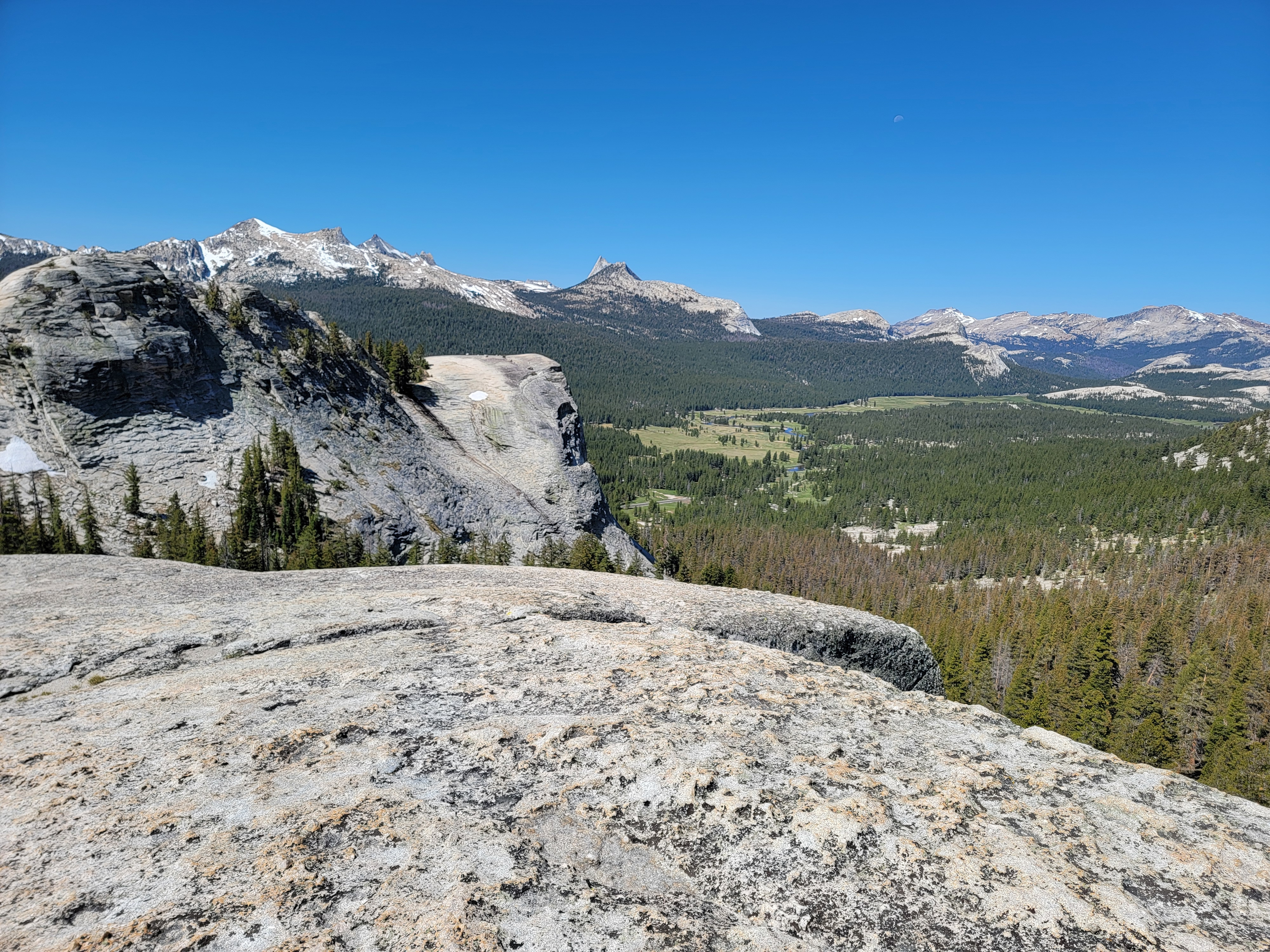
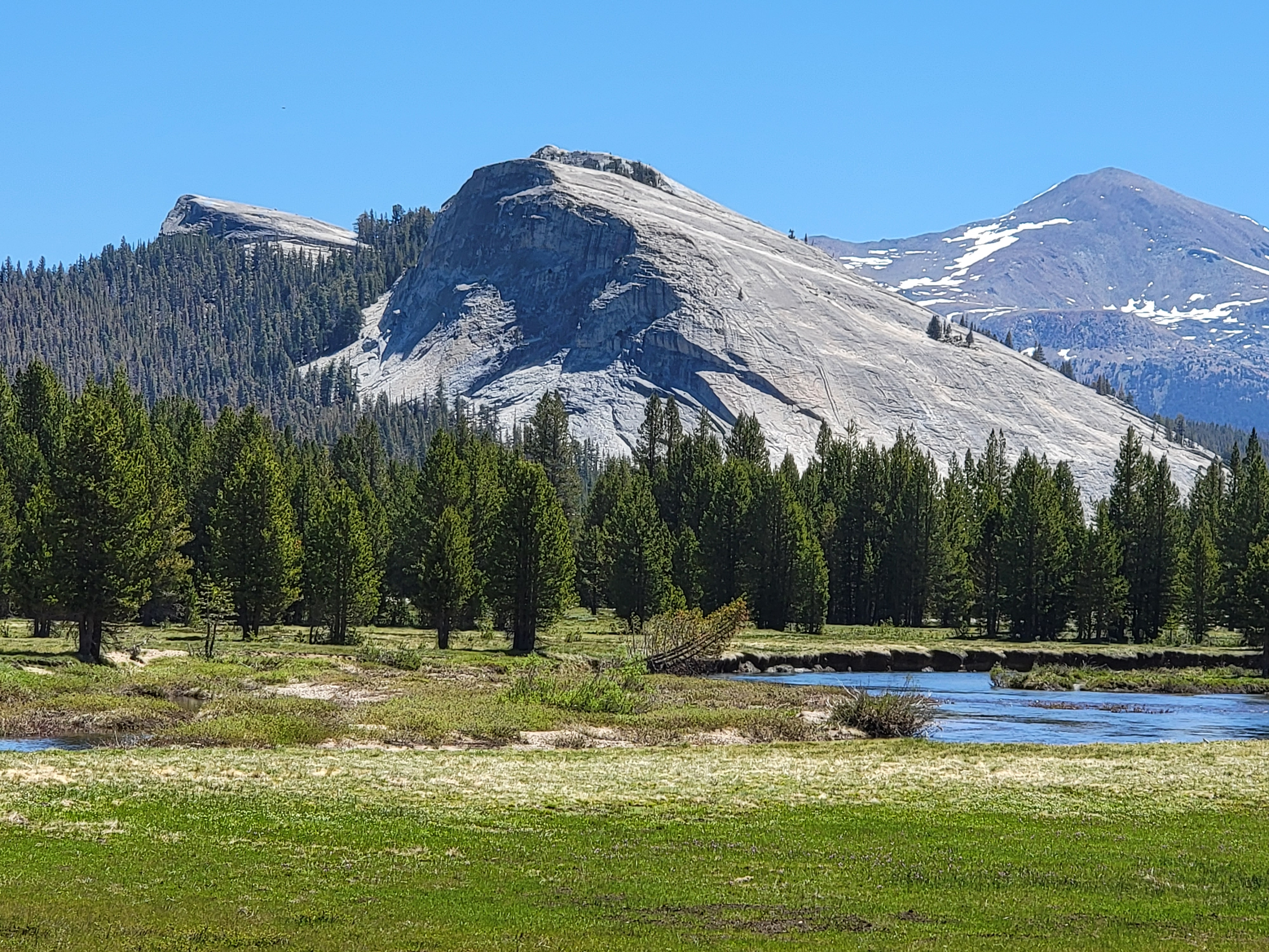 Tuolomne Meadows - Dog Dome, Lembert Dome and Mt. Dana
Hey, as long as I am trying to get a permit for The Wave, I thought I would put in for a permit to do Angel's Landing. It's a hike in Zion National Park that also requires a permit obtained through a lottery. I've done it about five times already but it's one of those hikes that you can't do too many times. It would be my backup. Then as long as I was on recreation.gov entering lotteries for permits, I thought I would put in for one more hike that required a permit - Half Dome in Yosemite National Park. (See. I told you that if you were patient I would get around to it.)
Well, I heard back from recreation.gov after the drawings for the lotteries. I did not get a permit for The Wave. I did not get a permit for Angel's Landing. But I did get a permit for Half Dome. It takes a lot of luck to win one of these permits. They're too valuable to waste. So because I wanted to go hiking on my way to Phoenix I ended up planning a different trip to climb a mountain in central California. Weird huh.
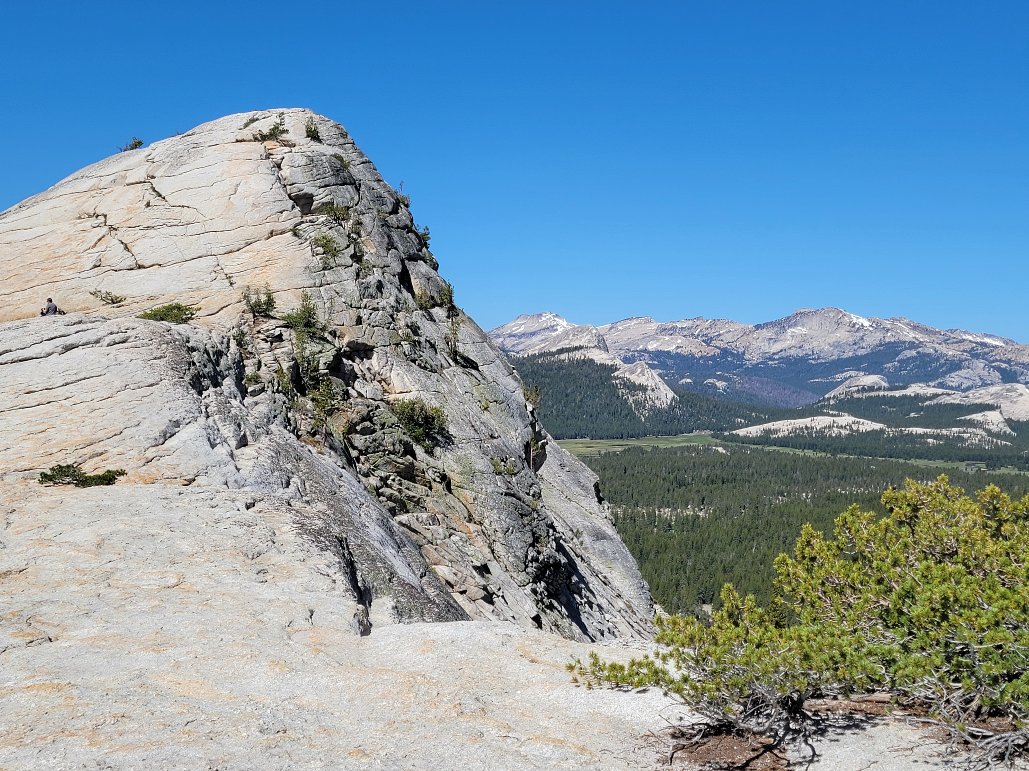 Approaching the top of Lembert Dome
This June is busy. We just got back from a week on the Olympic Peninsula. Next week the grandkids are coming to Boise to visit. I don't have a lot of time to squeeze this trip in. But I didn't need a lot of time. You can do Half Dome as a three day backpacking trip. Camping in Little Yosemite Valley means no long approach hike before tackling the tough summit section. But permits for camping in Little Yosemite Valley are even more limited. I didn't have one. I just had a day hike permit. So I had to do the whole thing in one day - hike from the valley floor to the summit and back down again.
I've done Half Dome twice before. In 1976, when I was a grad student at Stanford, I tried it with a friend. It was my first ever backpacking trip and we did everything wrong. Hiked too fast. Carried too much weight. Didn't take enough water. Hiked in the hottest part of the day. We both were totally wiped out by the time we reached Little Yosemite Valley and just went down the next day. I came back a month later with my brother Mike and we were successful. Three days, but we made it to the summit of Half Dome. It was my first major mountain climb.
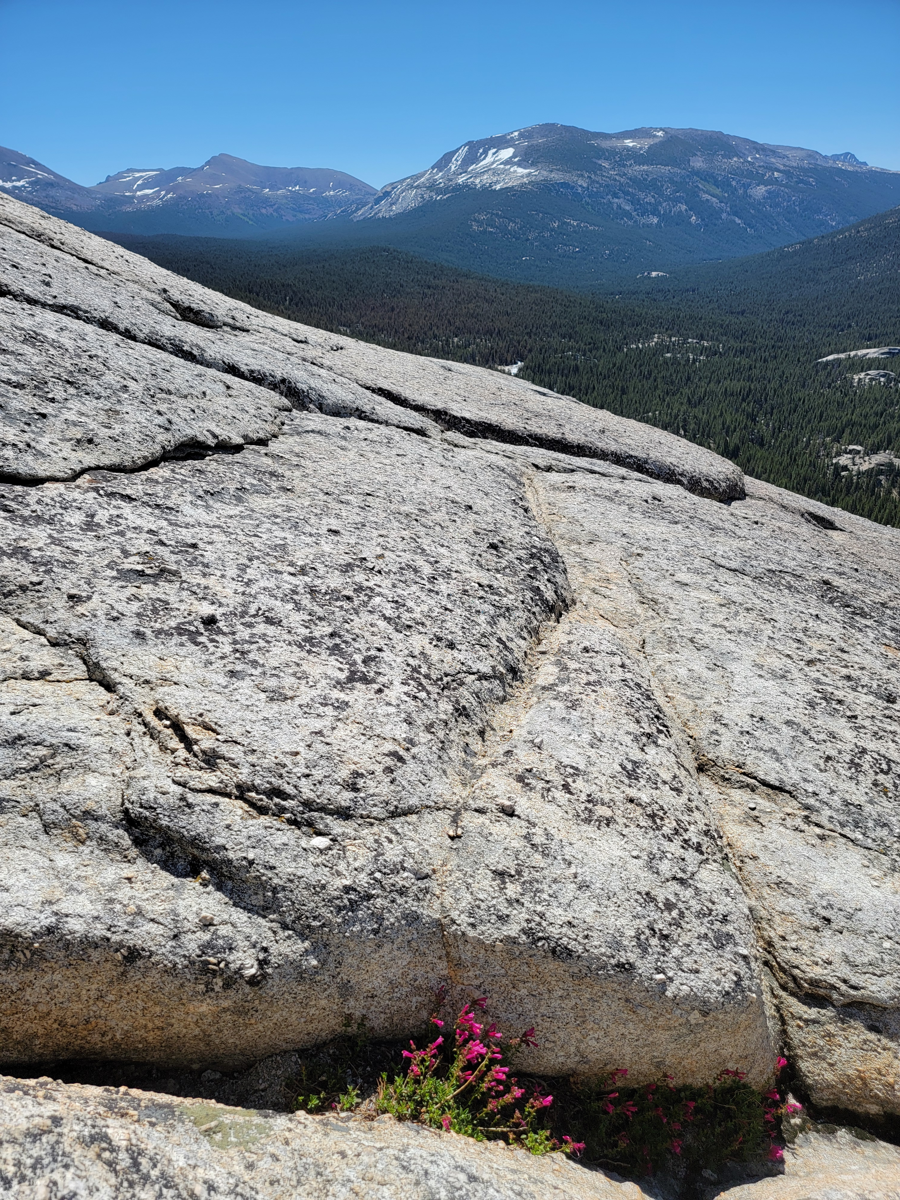 Hardy flowers on Lembert Dome
My second time was in 1999. I was trying to get my sons into mountaineering but they weren't interested. I made a deal with them. Go to Yosemite with me and climb Half Dome. It's one of the most impressive mountains in the World, and an incredible hike. If you aren't excited about hiking after that, I won't bug you anymore. They agreed. We started from Glacier Point and backpacked to Little Yosemite Valley. The second day we climbed the mountain and then hiked out on the third day. The trip was successful in that we summited but it didn't turn them into hikers. Oh well, maybe the grandkids.
Now I was going back to climb Half Dome a third time. I drove to Hawthorne Nevada, a town that is in the middle of nowhere. It's my normal stopping place when going to the Sierras and I stayed at the Holiday Lodge. It's nothing fancy but it's cheap and it's clean. The next morning I was up early and heading for Mariposa, a town on the east side of the Sierras, where I would spend the next two nights. Driving through Yosemite to get there would give me a chance to scout things out. Plus, I would be in Yosemite - always a good day.
It was a beautiful morning driving into Yosemite. The scenery along the Tioga Pass road approaching the park is fantastic and I stopped at a number of places to take pictures. Just to get into the park requires a permit, but I was early enought that the entrance station hadn't opened yet. My Half Dome permit gave me a park permit as well anyway, but I didn't need it this time. Still kind of sad to think that you have to win a lottery just to be able to enter the park. Too many people.
 Looking back to Lembert Dome from Dog Dome
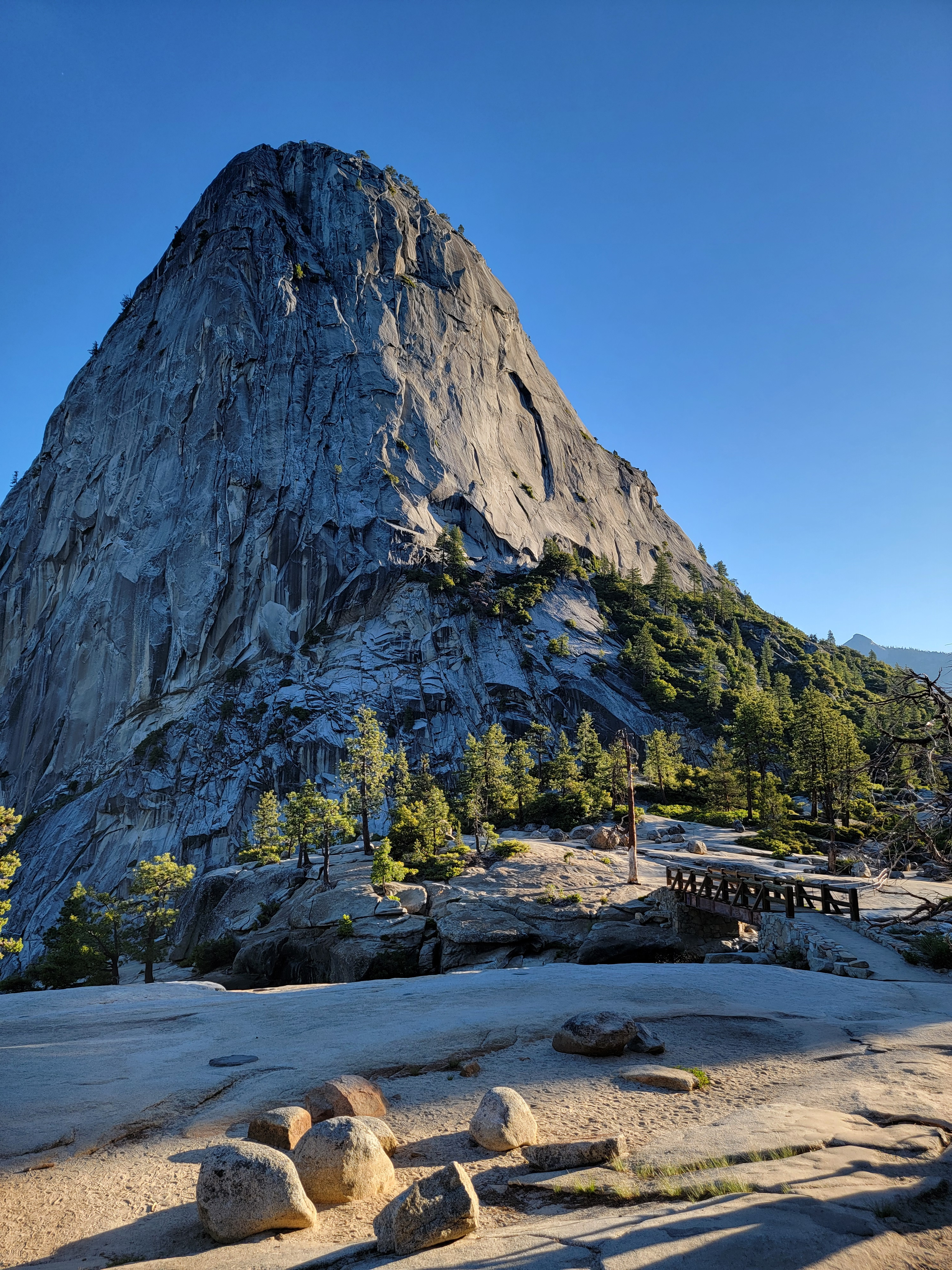
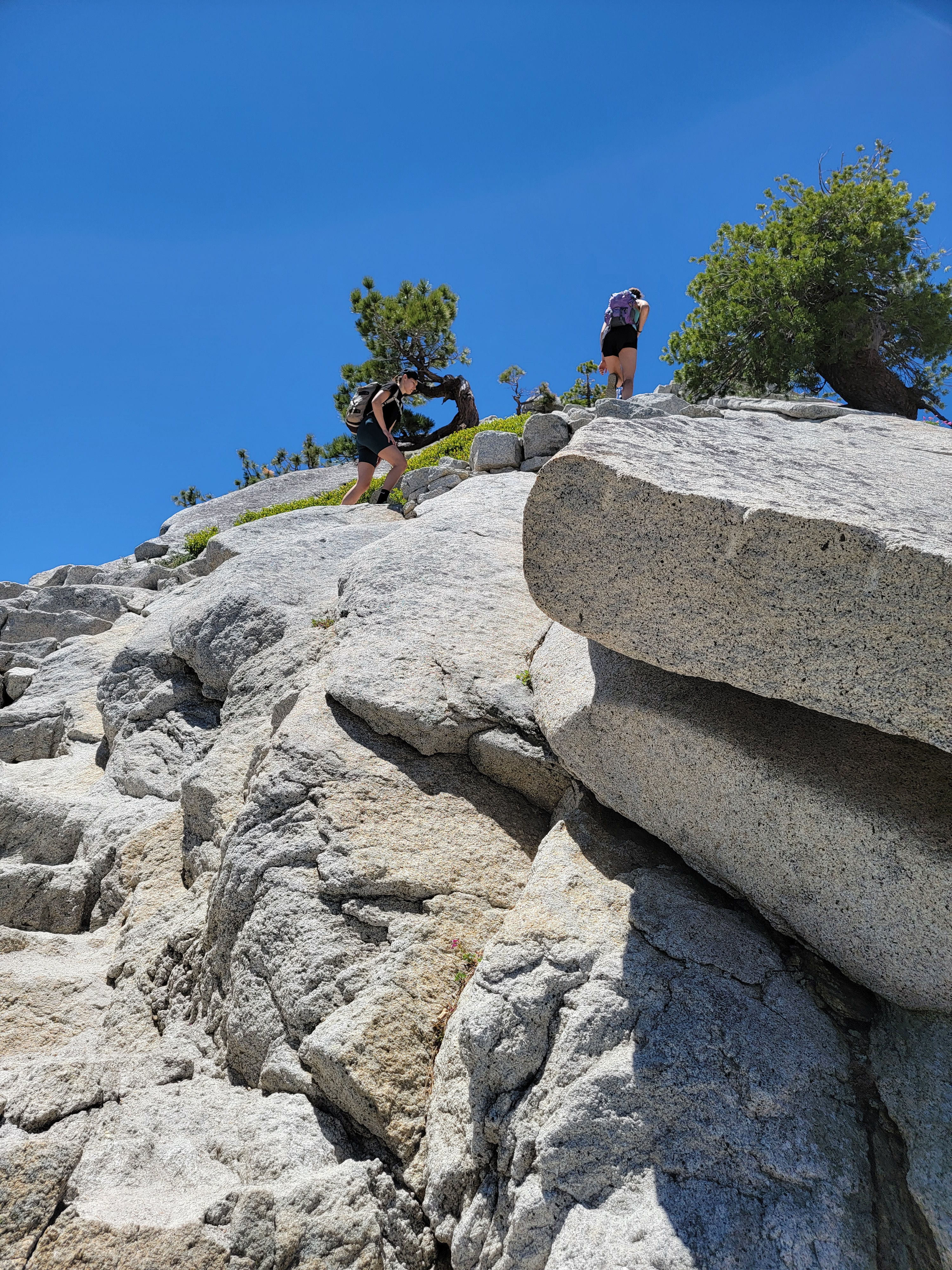
After checking out the Visitor Center in Tuolomne Meadows, I parked at the Lembert Dome trailhead. It's a fun hike to the top, about a mile long and 700 feet of elevation gain, The last third is on the granite of the dome, which steepens considerably as you get near the summit. Going straight up is a significant scramble, although not too difficult. I was feeling lazy today, so I traversed around about 120 degrees to where the slope was less steep. The view from the top is spectacular and going up the steep granite slabs near the top was good practice for tomorrow's hike up Half Dome.
On the way down I took a short detour and went up nearby Dog Dome as well. It was easier than Lembert but hey, I couldn't resist climbing something named Dog Dome, could I?
Back in my car, I drove around to Yosemite Valley. It's one of the most beautiful spots on earth so I decided to brave the crowds that I knew would be there. I parked and took the short walk to Bridalveil Falls, along with about a million other people. Of course the falls were impressive. Next I parked where I could get a good, up close view of El Capitan. It made me think about watching the movie Free Solo when I got home.
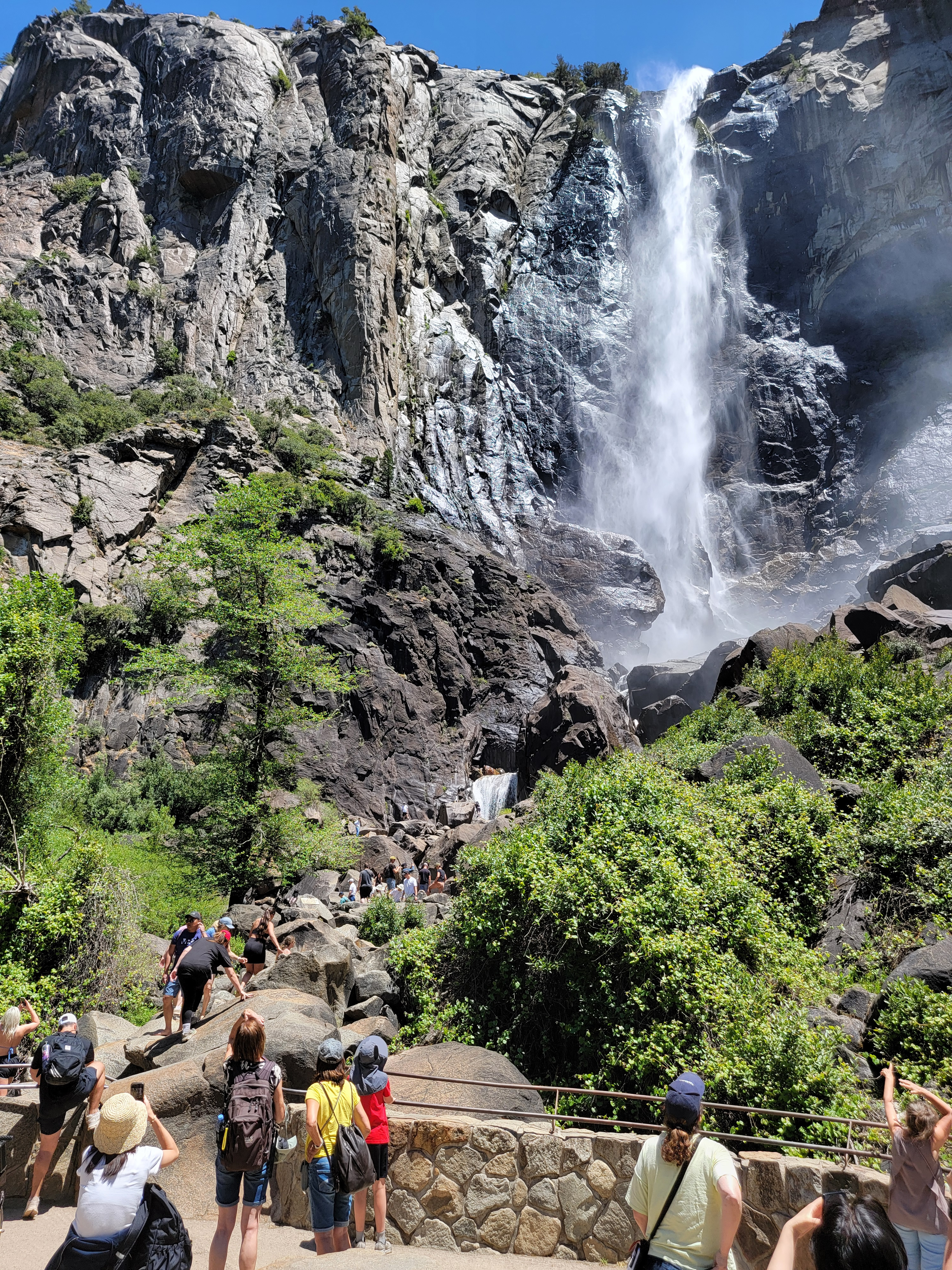 Crowds at Bridalveil Falls
Finally, I did the most important thing. I drove down to look for the parking I would use the next day. It was tough going. The end of the valley was clogged with cars, buses, bikes and people. The trail starts from the Happy Isles Trailhead, reached by the shuttle operated by the Park Service. But it doesn't run as early as I would be starting out, so I would have to drive, and park, my car. Unfortunately, there was a sign saying "Shuttles Only" about three quarters of a mile from the trailhead. Great. Another mile and a half added to the hike tomorrow. The map showed ahikers parking lot closer to the trailhead, but it didn't do me any good if the road was blocked off.
Leaving the park, it was about an hour drive to Mariposa. I checked in at the Mariposa Miners Inn Motel and walked down to the Pizza Factory for dinner. I needed to fortify for my big day tomorrow. Then it was back to my hotel to try to get some sleep. I needed a ridiculously early start the next morning. I got everything ready for tomorrow, but then of course, since I was excited, I couldn't fall asleep. I maybe got an hour or two before it was time to go.
The Big Day. I had a tough hike ahead of me - about 20 miles and 5000 feet of elevation gain. Plus I had to do the cable route. I was out of bed at 3:15 am and in my car and on the road by 3:30. The drive took about an hour. There was no one around. I considered going around the gate blocking the road to the trailhead, but decided against it. Who knows. They might tow my car away or something. That would be the last thing I would need at the end of a long day.
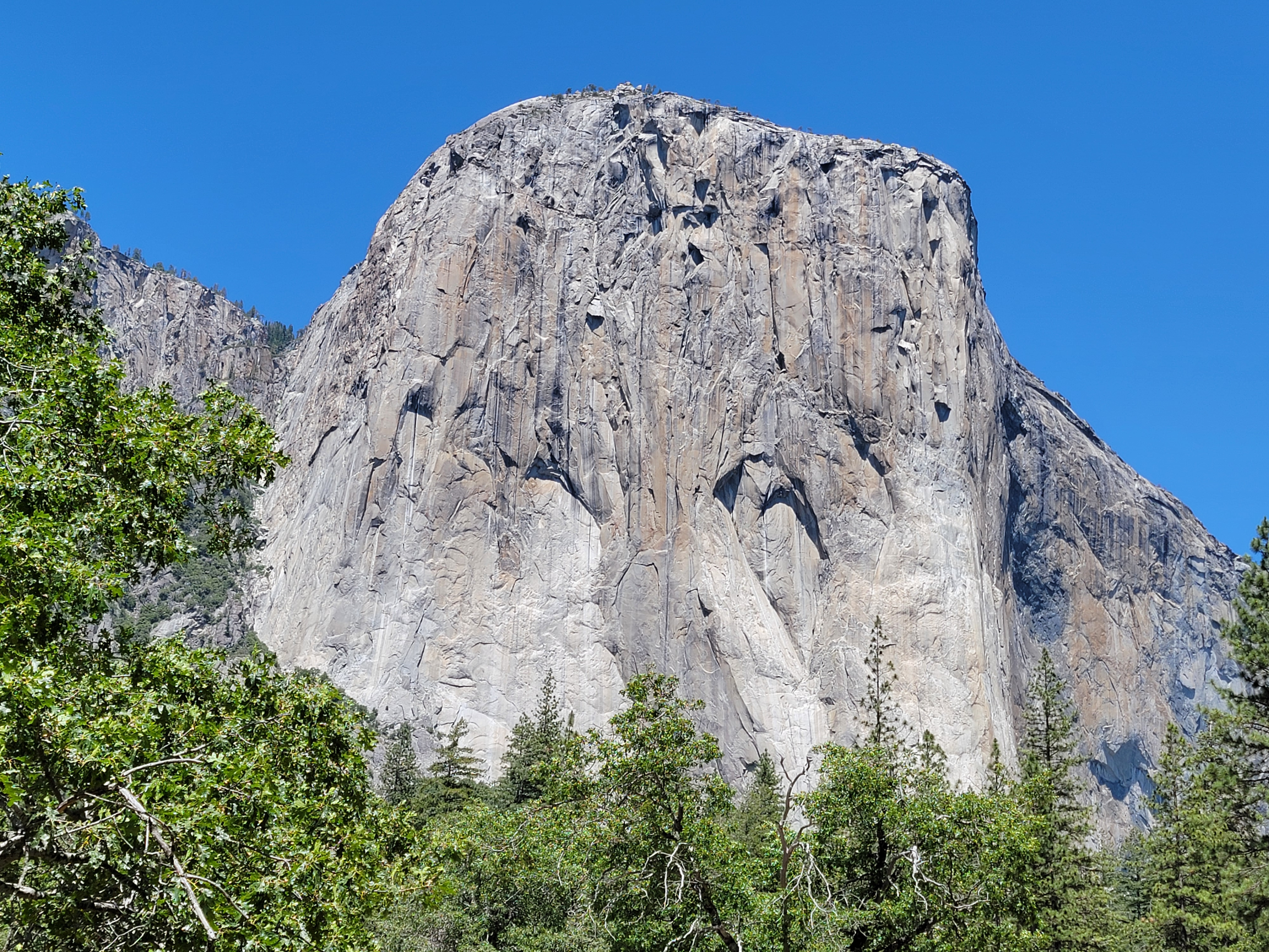 El Capitan - I have a sudden urge to watch Free Solo
I parked on the main road and started out at 4:30. For the first twenty minutes I was walking on the road. Although it was very dark, the road was wide enough and even enough that I didn't need my headlamp. I could make my way just by starlight. It was kind of a neat experience, walking in nearly pitch darkness and almost total silence.
When I reached Happy Isles I turned onto the trail that followed along right beside the river for the next mile or so. It was an excellent trail so it was easy going, but at this point I turned on my headlamp. Going off the trail into the river would be very serious. People have drowned along this section. But it was weird walking in a little bubble of light with what seemed like total darkness beyond it. I could hear the river roaring right next to me, but I couldn't see it. This part of the hike was an interesting experience too, even if I wasn't able to admire the scenery.
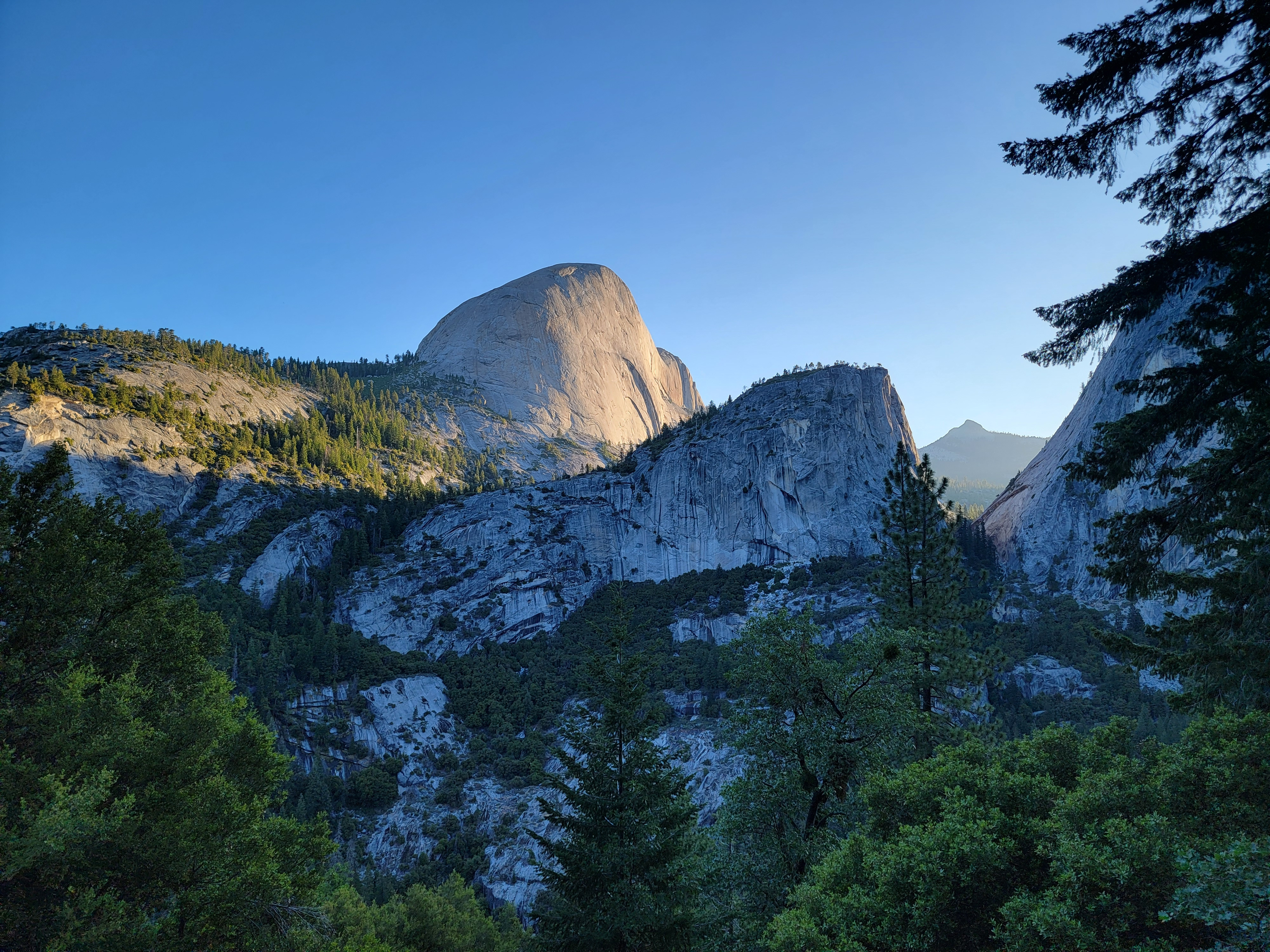 Dawn Light on Half Dome - the route is on the far side
Just over three quarters of a mile from the trailhead I crossed the Vernal Falls footbridge. Not much past that was a trail junction and a decision point. The Mist Trail ascends along the river. It's very steep. Much of it is stone steps. The alternative, the John Muir Trail, has a series of switchbacks that ascend more gradually. The two trails join again above Nevada Falls. The JMT adds three quarters of a mile in each direction, but I opted for that. The name of the Mist Trail should be a dead giveaway. You usually get soaked by spray from the falls and the river. The stone steps are slippery when they are wet, and they are always wet. There is also some exposure, and I would be going up in very faint, early morning light. Much as I hated to add mileage to what was already going to be a very long day, I took the John Muir Trail. Maybe it wasn't as steep as the Mist Trail, but I thought it was still pretty steep. I just took it slowly. As I climbed higher, the sky gradually got lighter. By the time I reached Clark Point, the first viewpoint where I could see Half Dome, the morning sun was already shining on it.
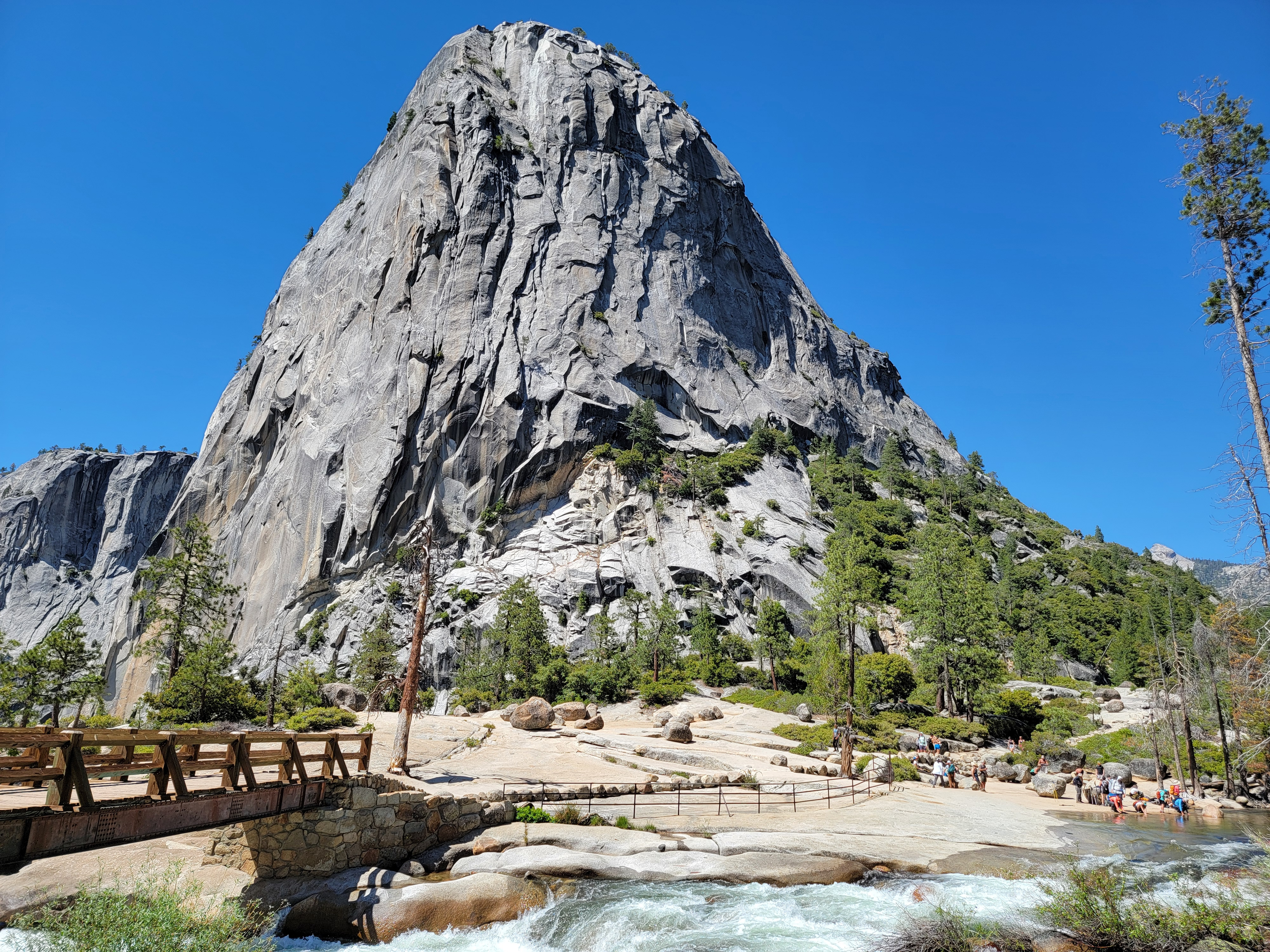
 Liberty Cap and bridge above Nevada Falls
The trail flattened out as I approached the top of Nevada Falls. I crossed a footbridge over the Merced again, right at the top of the falls. It was a spectacular spot, with the huge stone monolith of Liberty Cap looming overhead and the waters of the Merced roaring under the bridge and over the falls. There was no one else here. I had this special place all to myself. It would be quite different when I reached here on my way coming down.
Another quarter of a mile and I reached the junction with the top of the Mist Trail. There were several people taking a break there and from that point on there were quite a few other hikers. I guess that most people take the shorter route to save themselves the extra distance. I wouldn't have the trail mostly to myself anymore. Since I'm a slow hiker, there was now a pretty steady stream of people passing me as I continued up.
The next mile plus was pretty flat, which was a welcome relief, until I reached the spur trail that led off to the Little Yosemite Valley campground. Although it's in the backcountry, the Park Service has hardened it considerably. Camping is only in designated sites. There are special, solar-powered, composting toilets. Even with that, there is a strict quota system and it is pretty hard to get a permit. It's not like my first time way back in 1976 when my brother and I just hit the trail and camped there. Too many people.
 Mt. Starr King in the distance to the south
Where the trail turned and started up the hill again, there was a group of people clustered around. The ranger was there, checking permits. She was based at the campground and usually climbed up to the base of the cables to check permits. She said that she wasn't feeling well today, so she was checking permits here. I waited my turn and got cleared to continue. She gave a little lecture to the group on not going up the cables if the weather was at all threatening. Lady, you didn't have to tell me that.
At this point I had done about half the distance and 40% of the elevation gain to the top. A healthy hike already but I felt great, which was good because I still had a long way to go. I started up the hill and the trail immediatly went into the forest. It climbed at a reasonable but steady rate. I just went slowly. There were lots of people on the trail now. Of course all of them were faster than I was and would pass me. They were friendly so as they went by they would ask "Hey, how's it going?" I would always answer "I'm old and slow, but I'll get there!"
 Clouds Rest from the ridge
One guy finally asked how old I was. When I told him that I was going to be 72 next month, he looked surprised and turned to his friends. "Hey, this dude's 72." Then he turned to me and said "Good job, man!"
Even though hikers were passing me, they would often stop to rest further on, while I would just keep going, catching up and passing them. We would keep leapfrogging each other. I started to recognize people and each time we would pass we would chat a bit. After a while it seemed like all of us on the trail were getting to know each other.
Mosquitoes were a minor annoyance on this section, although they weren't too bad while I was moving. That provided more incentive for me to keep moving slowly and not stop to rest, which was my natural inclination anyway. It helped that the little blood suckers were very slow and easy to swat. I got at least half a dozen of them before they had a chance to bite. Spoiler: at the end of the hike I had zero bites. So the final score for the day was Steve 6, Mosquitoes 0.
 The objective finally comes into view
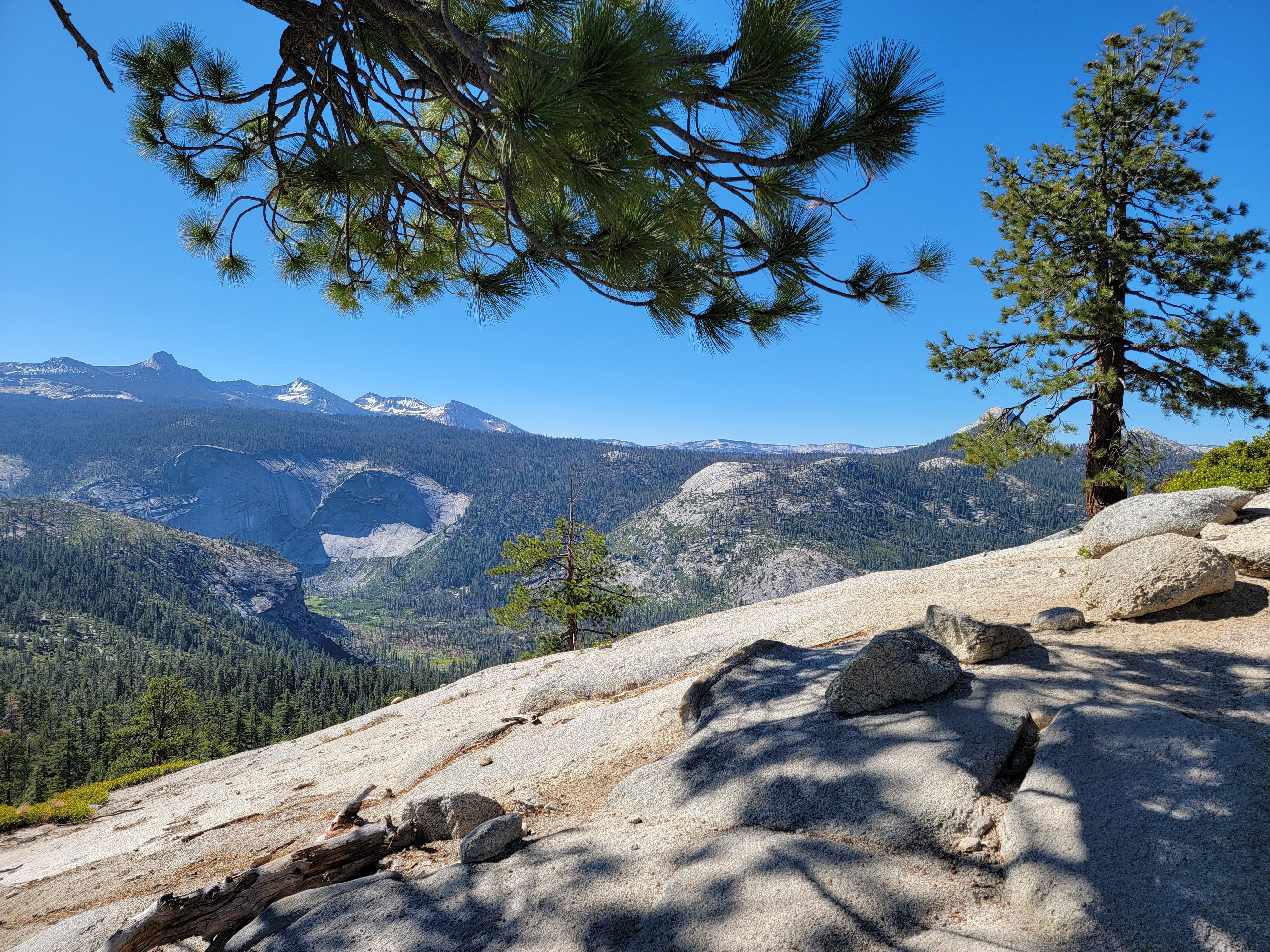
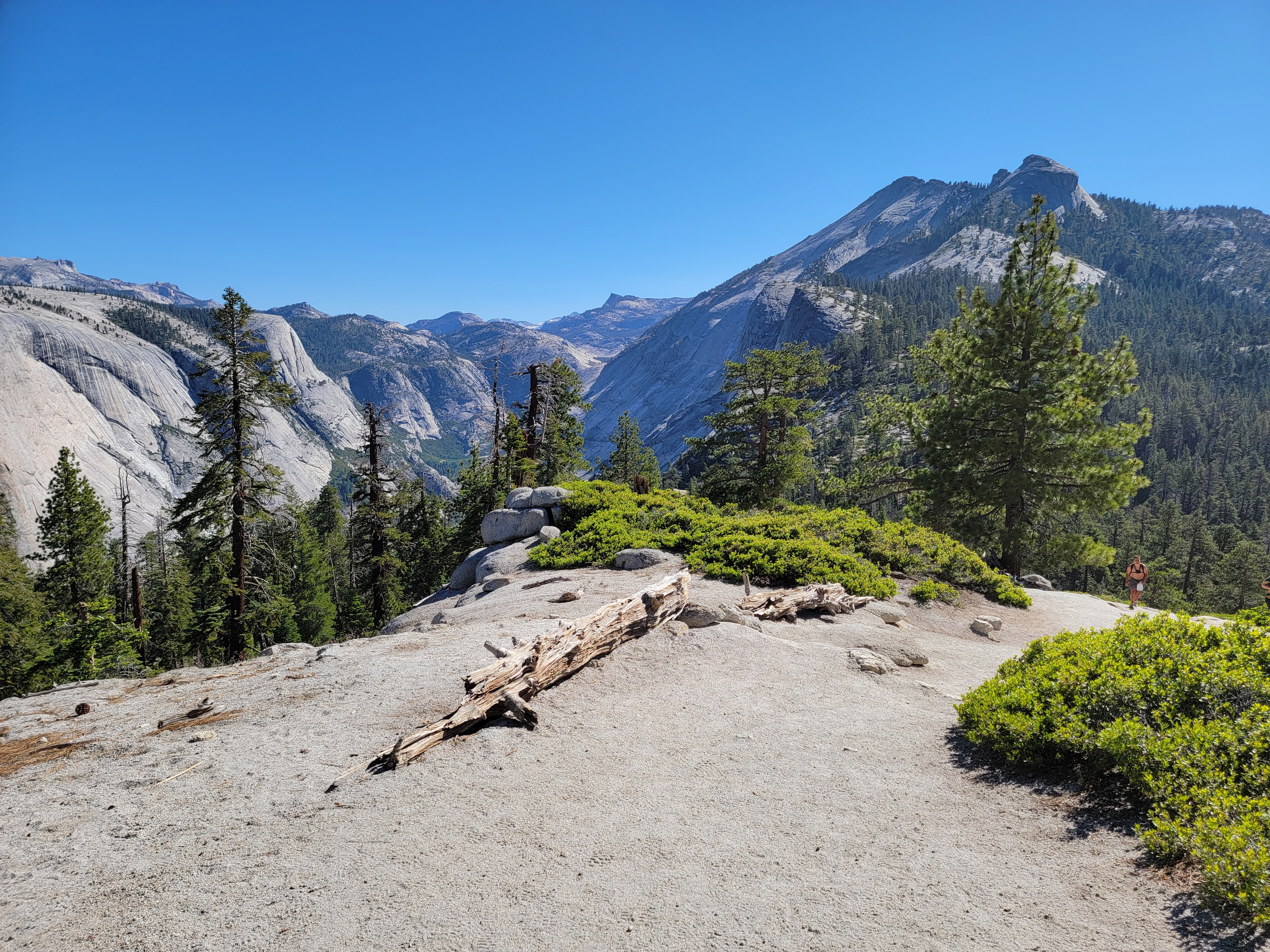
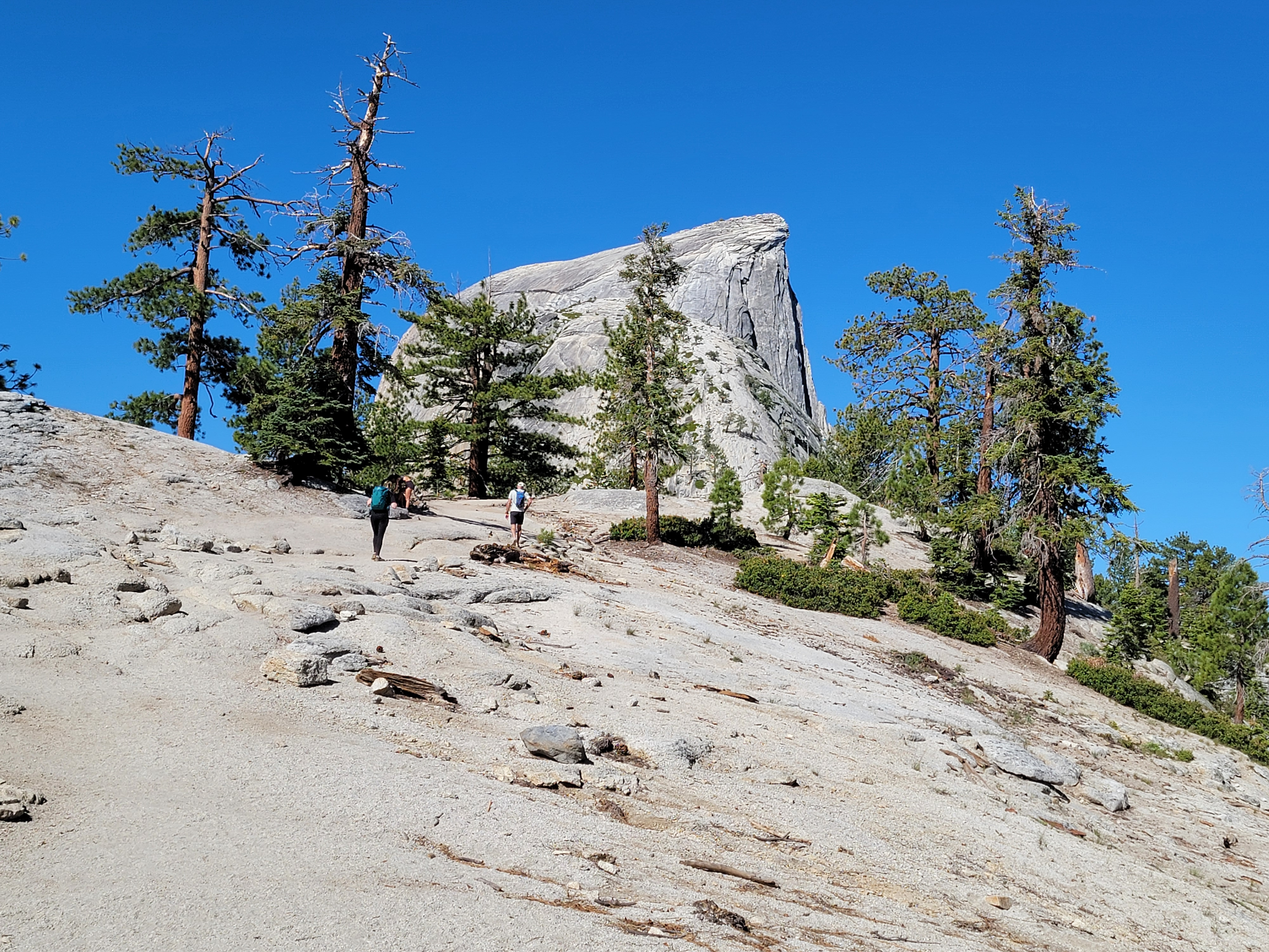
The switchbacks seemed to go on forever, but eventually I reached the crest of the ridge that extended from Half Dome to Clouds Rest. Now the scenery was getting impressive. The forest was opening up, so the views were more expansive. Over the ridge was Tenaya Canyon and North Dome. To the east was Clouds Rest. And now to the west Half Dome was visible, still a ways off but no longer impossibly far. The subdome loomed large, with the upper part of the final slope of Half Dome showing above and behind it. Still a long way to go but I was getting there.
Recharged by the sight of the final objective, I enjoyed the hike up the ridge. Whether it was the thining forest or the light breeze across the ridge, the mosquitoes were gone. Stops were pleasant and I would make short ones whenever I encountered a group that had taked a rest break. I'd pause and chat for a minute. By now it seemed all of us on the trail were getting to know each other and we all shared the common goal that rose ahead of us - the summit of Half Dome.
 Hikers climbing the subdome
At the base of the subdome there are large, ominous signs placed by the Park Service. They remind you that a permit is required at all times to go beyond the signs onto the subdome and cables. They warn you that the hike is dangerous, that people have been killed higher up by lightning and falls. I really doubt that anyone who gets to this point is dissuaded by ths signs and turns around and goes home.
The trail ends at the base of the subdome. From that point on, I was hiking on granite. The subdome is steep and there is some mild exposure. Some of the guides that you find on the internet say that the subdome "is a serious scramble", but I didn't think it was hard to find a fairly easy route up it by taking reasonable care. Part of the way up is on steps cut into the granite. Part of the way is up slabs. Yosemite granite is hard and provides a lot of friction when walking up slabs. As I had done all day, I just took my time.
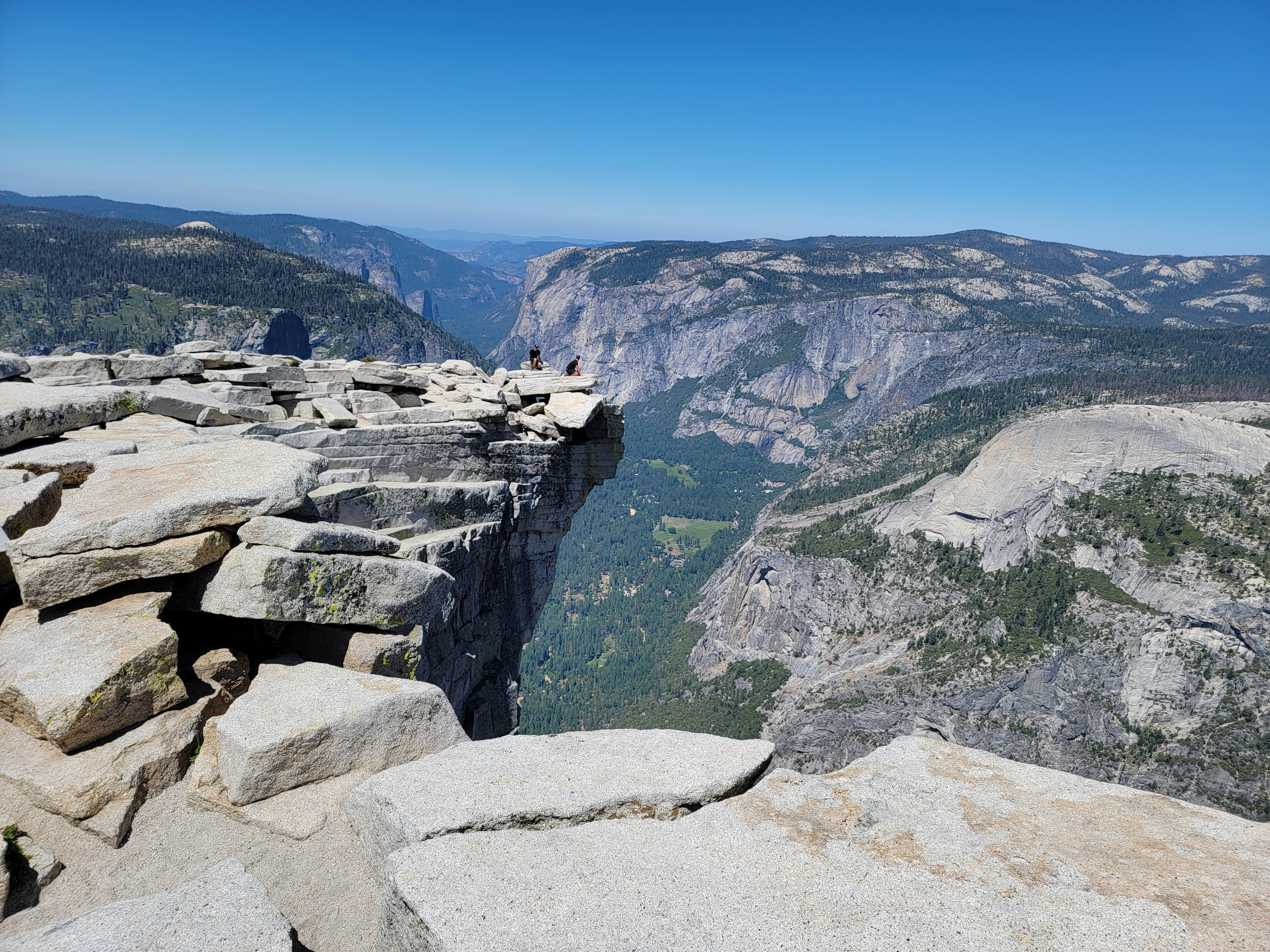
It's four hundred feet of elevation gain to the top of the subdome. When I reached the top the view of the mountains all around was amazing. But my gaze was fixed ahead of me. A slight dip led to a small saddle where a number of people were clustered. Beyond that was the steep granite slope that led to the summit of Half Dome. It's the grand finale, the famous cable route. The first view of it is quite striking. Some people are intimidated. Some are excited. But no one is unaffected when they first see it.
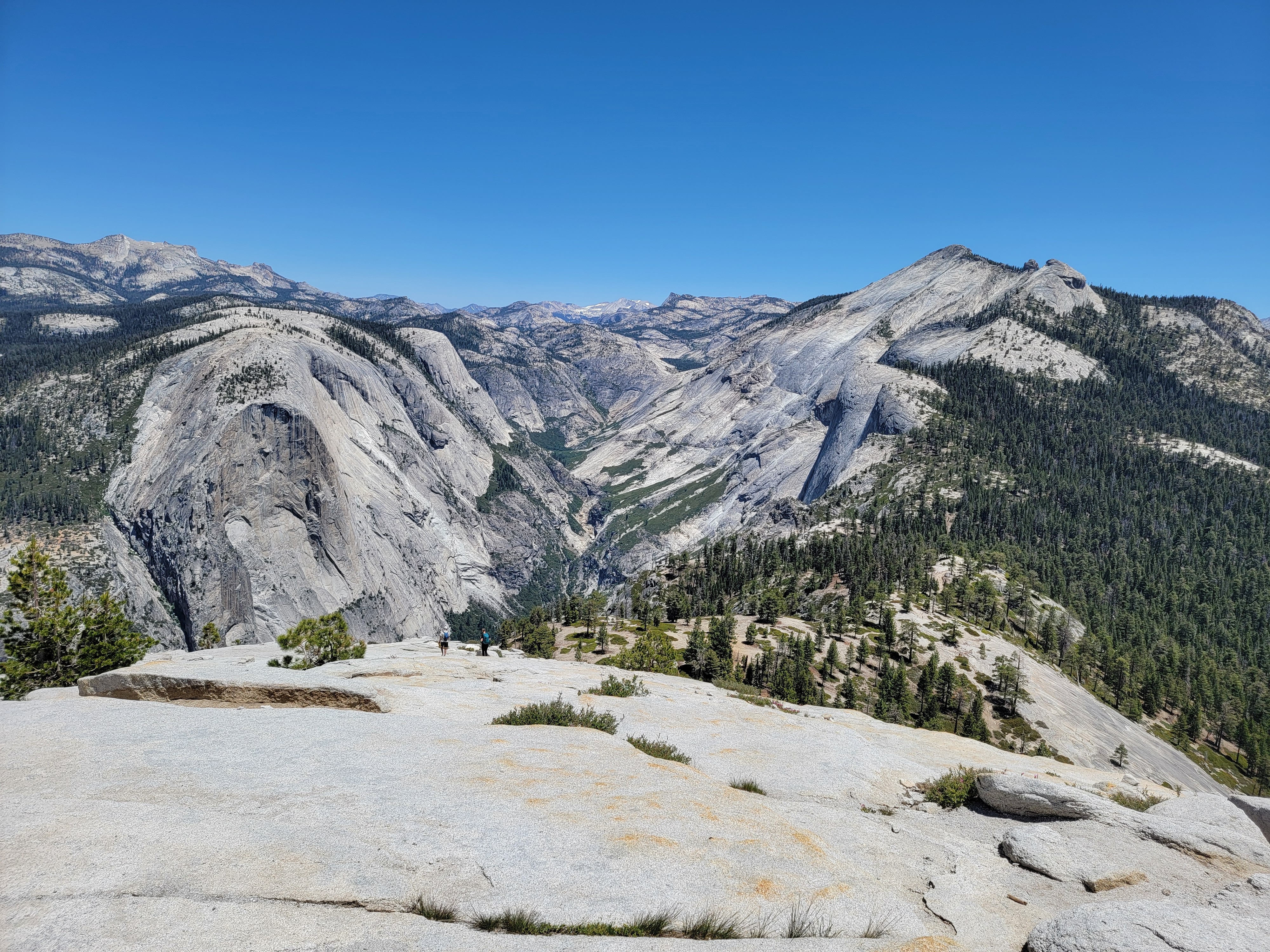 North Dome, Tenaya Canyon and Clouds Rest from the subdome
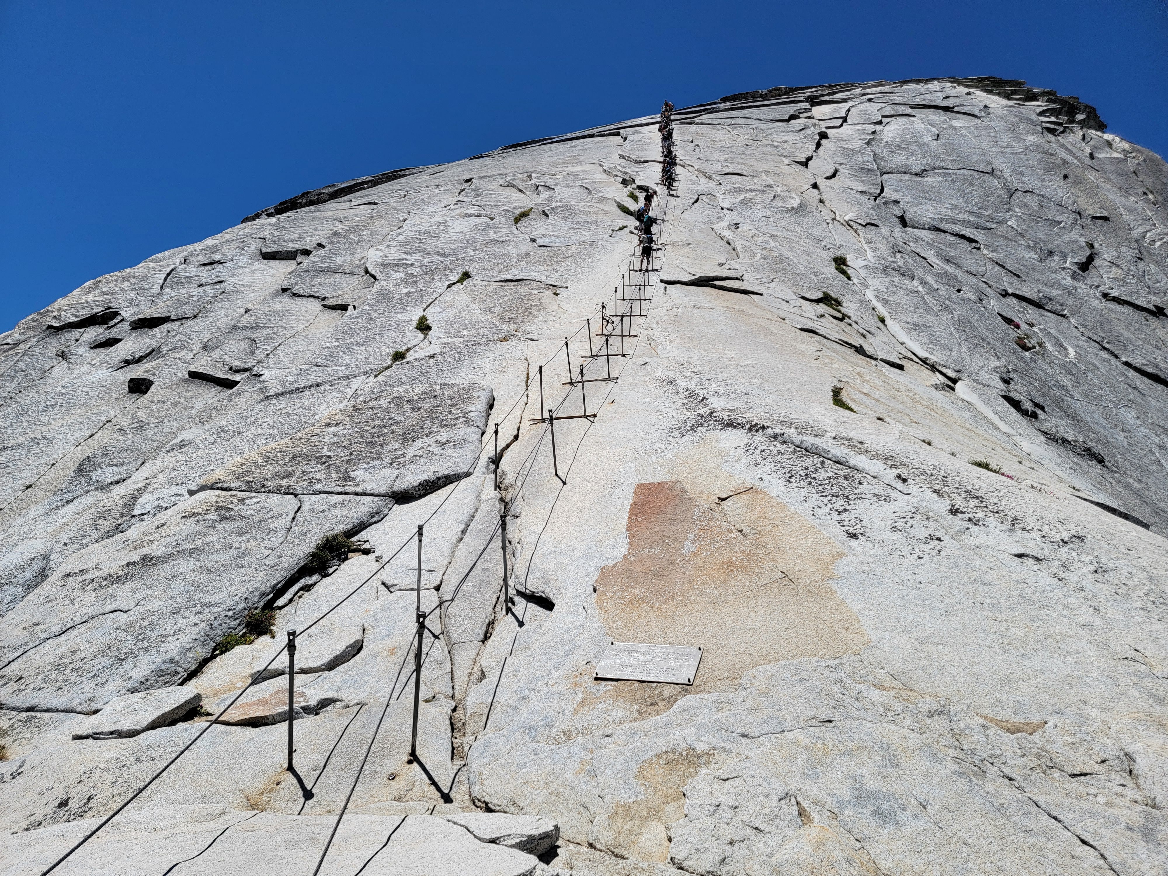
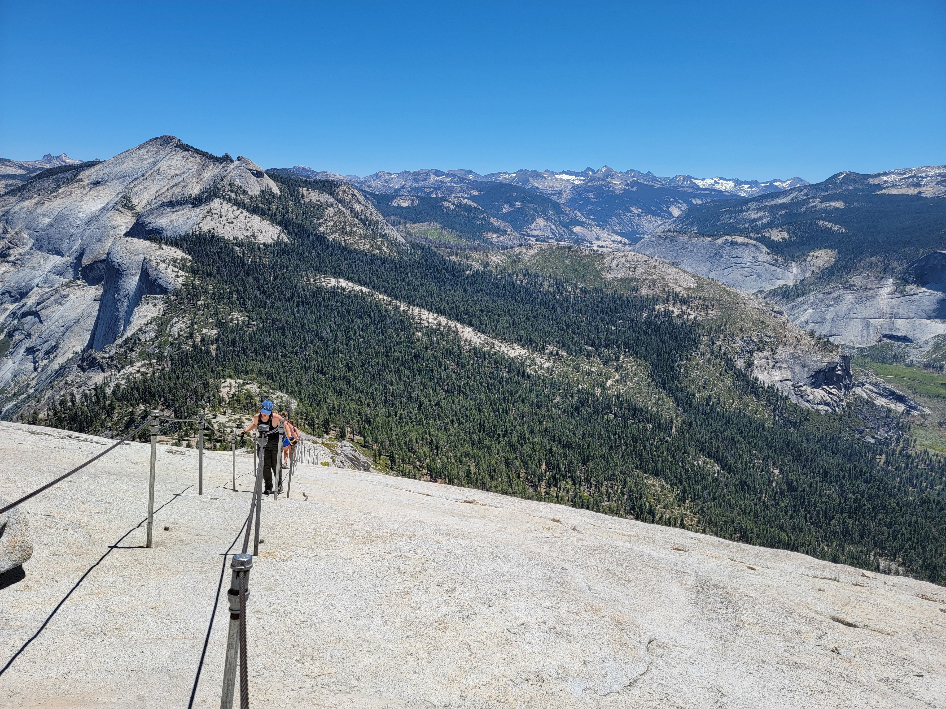
The final four hundred feet to the summit is up a single 45 degree granite slope. Without aids, it would be a roped rock climb as a fall could be fatal. To make it accessible to hikers, there are two steel cables that run down the length of the slope. They are held up by stanchions so that they are at waist height, about four feet apart. They're close enough that you can hold one cable in each hand as you climb, but allow enough room for two hikers to pass each other. There are wooden planks every six to eight feet, supported by the poles. They allow you to stop and rest while on the cables.
The cable route is serious. There have been a number of fatalities over the years. Most were due to bad weather, rain making the granite extra slippery. Some were due to medical problems, like a heart attack while on the cables. Some occurred when the cables weren't up, as the Park Service only puts them up in the summer. At least one was due to crowding. The hike became so popular that for a while as many as a thousand people a day were doing it. This created dangerous traffic jams on the cables. In 2010 a permit system was started. Now the number of hikers is limited to 300 per day. The demand is so high that only about twenty percent of people who apply get permits.
 On the top of the subdome observing people on the cables
I saw that a few people were using via ferrata gear to clip into the cables. Maybe it was ten percent. Sure, the route is serious, but I thought that was overkill. I wasn't too worried. I had done it twice before and didn't think it was that bad. The rock was dry and there wasn't a cloud in the sky. You just had to be careful. I took a break at the top of the subdome and watched people on the cables for a while. Even with the permit system in place, they were crowded. Since people were going up and down, they frequently had to pass someone going the opposite direction.
After observing for a while, I thought it was time to get started. I put on a pair of gloves that I had brought along, heavy work gloves with a good grip for holding onto the cables. Everyone brings a pair. I fiugured this was going to be easy. Move slowly. Get a good grip with my boots on the grainte to step up. Hold onto the cables for balance and security.
 At the base of the cables
It was only a few steps before the rock steepened and I got a surprise. The rock was slick and didn't provide much traction. Those thousands of people who had gone up and down since I climbed here over twenty five years ago had worn the rock smooth. Ascending required pulling myself up with my arms rather than stepping up with my legs. Unfortunately I've never had much upper body strength. I got tired very quickly and had to stop at every plank to rest. This wasn't so easy.
I reached a point where I had to make a decision. I was already exhausted, but I was only a quarter of the way up. Do I descend or keep going? I thought about it for a while and decided to keep going. But I had to shift to a lower gear. I would move from one plank to the next, and then stop and rest for as long as I needed to get my strength back, at least enough to tackle the section to the next plank. I was probably the slowest person on the cables so I had to let people coming up behind me pass. I quickly developed a technique. I would hold tightly to the pole and hunker down as close as possible to it. Then the other person could use the cables to pass me. It worked pretty well.
 Me on the summit of Half Dome
I wasn't the only person going slowly. There was a wide variation in speed among the people going up and down the cables. Even with the permit system there were twenty to fifty people on the cables at any time. You had to pass people going the same or the opposite direction a lot. Everyone was polite. Everyone was careful.
I was probably the slowest person on the cables. I didn't time it but I think it took me about an hour to climb that last four hundred feet. But I made it. Wait, let me say that again.
I MADE IT!!!!!!
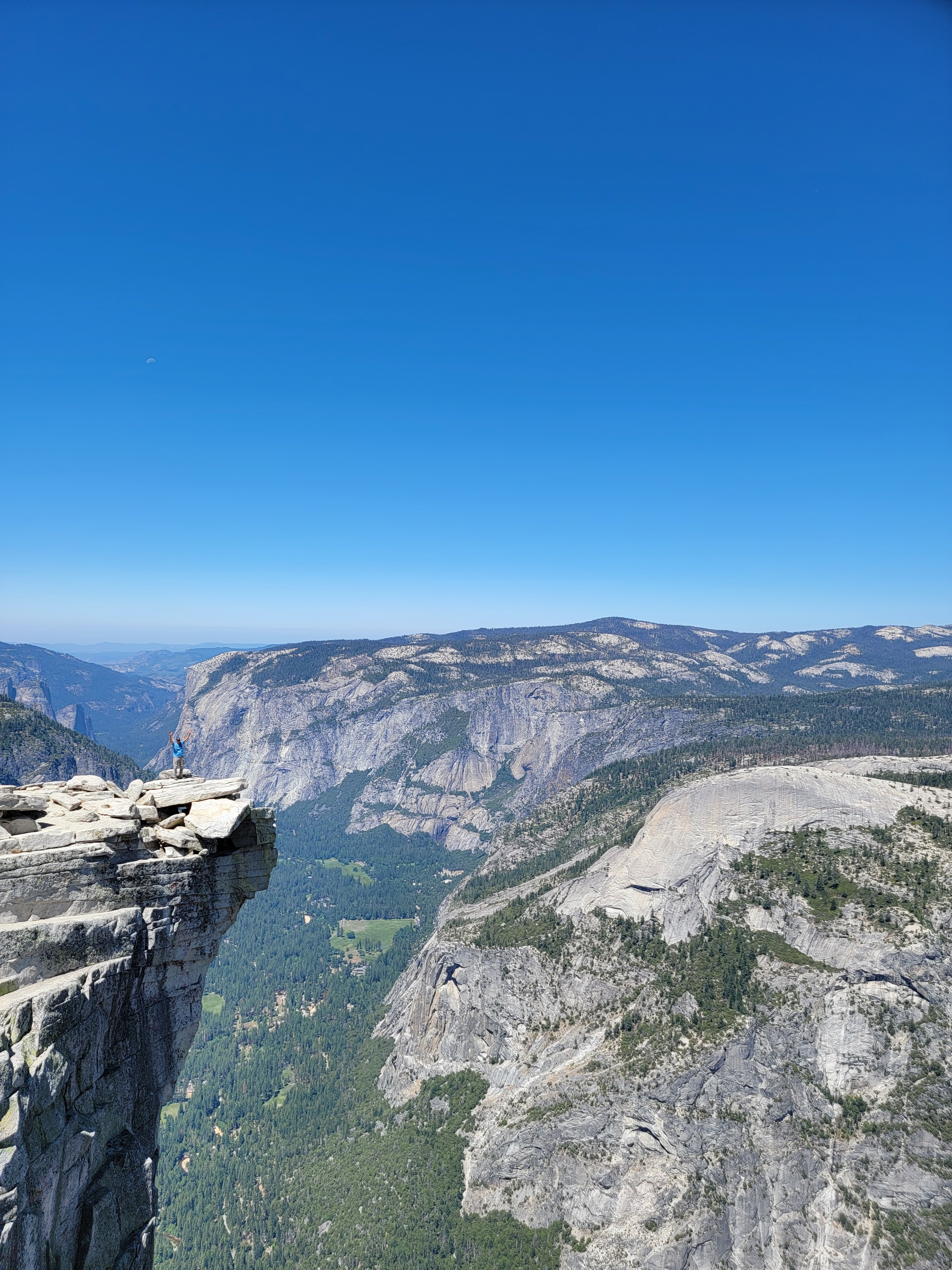
The summit of Half Dome is a huge, flat area. You could probably fit a football field up there. Usually I look around to try to determine exactly where the true summit is. Not this time. Up the cables counts as getting to the top in my opinion. There were probably fifty people on the summit but there was lots of room. I found a rock and plunked down for a well deserved rest.
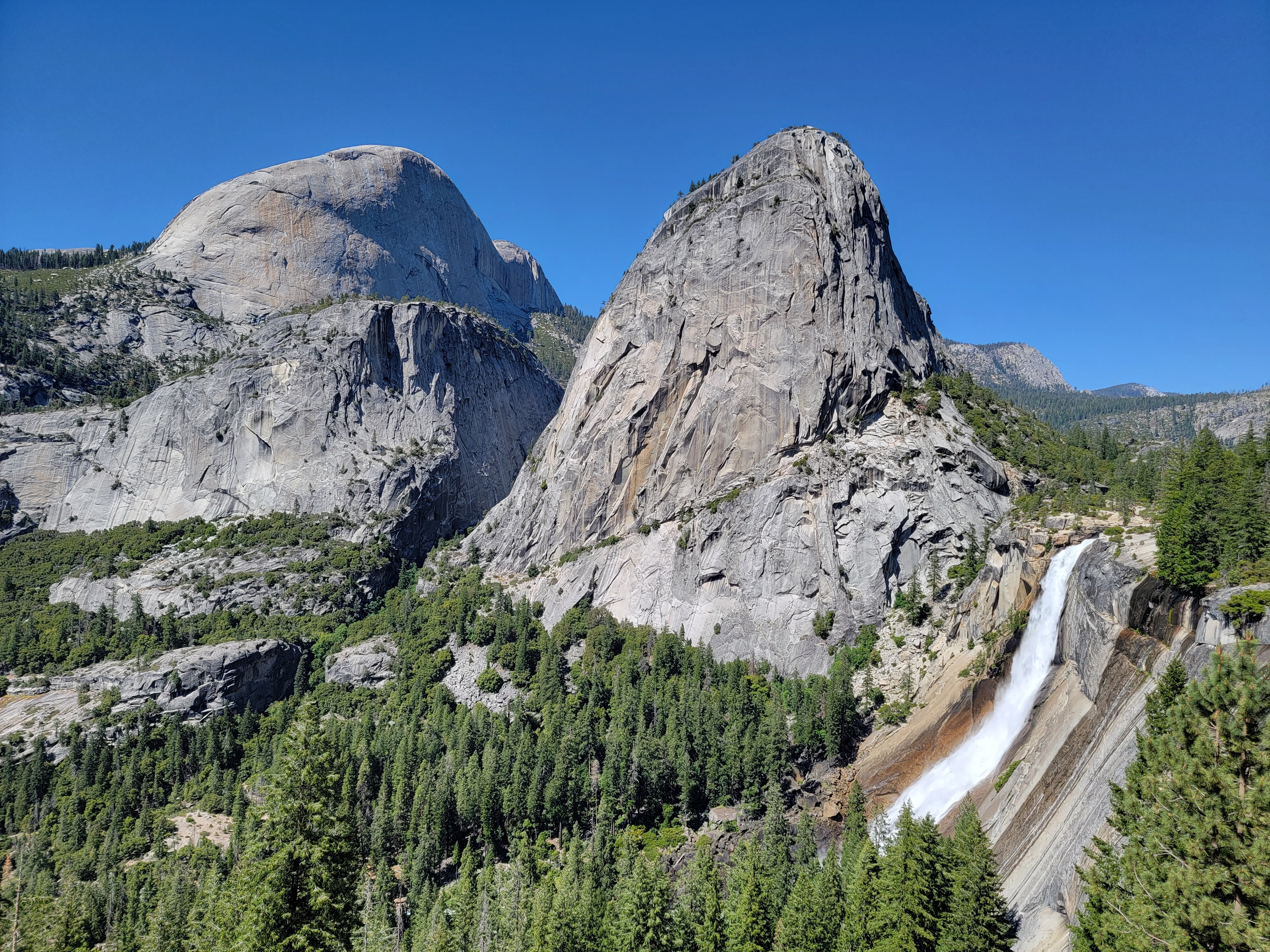
The view was tremendous. To the west I could see El Capitan and Yosemite Valley. To the east was Clouds Rest, perhaps the largest masses of exposed granite in the world. I had climbed it once but resolved now to do it again later this year. (Check back with Dog Blog to see if I actually do it.) North Dome rose on the other side of Tenaya Canyon. Sandy and I hiked to it once. The view of Half Dome from there is amazing. To the north the view extended to Mt. Hoffmann and other peaks in the Tuolumne Meadows area. To the south was Mt. Starr King and mountains heading off to the distant John Muir Wilderness. It was a perfect day with a cloudless, blue sky and I just sat enjoying the view. Everyone sitting around was chatting. There was a real sense of comeraderie among all of us after tackling the long trail and making it up the cables.
 The standard spot for photos on the summit
I drank some water and ate a snack. I took photos. There is an outcropping that is the standard photo op while on the summit. People would give their camera to someone to take their picture standing at the edge. I did it for several people and someone did it for me. Unfortunately he took a really poor photo, but I guess you get what you pay for. Usually on climbs I get to the top, spend five minutes, and then head down. I stayed on top of Half Dome for an hour. It was wonderful.
You know the old saying, "what goes up must come down". Eventually it was time to go back to the cables. My recollection from my previous climbs was that it was easier going down. But my past experience hadn't been a good guide this time on the way up. Fortunately it turned out that it was easier going down. I went down backwards, holding the cables and leaning back, sort of like rappelling. It gave my feet more friction and I could walk down backwards easily. I still had to hold some of my weight on my arms but I didn't have to lift myself up. I got down in about fifteen minutes. After that, going down the subdome was easy.
 Ready to start descending the cables
Descending the ridge was glorious. The trail is easy, with a mild downhill grade. The whole time you are looking at the view of Clouds Rest, Tenaya Canyon and North Dome. Add to that the fact that I was feeling really good about doing the cable route and making the summit. I didn't so much hike down the ridge as float down.
By the time I reached the saddle my euphoria had started to wear off. The trail turned downslope and got steeper. It seemed like there were a million switchbacks. It was midafternoon and it was getting hot. I knew that I had a long way to go and a lot of elevation to lose (sorry about that knees). Now it was just a slog. For quite a while I walked with two guys, early twenties, who were also going slowly because one of them felt really sick. After stopping several times he told us to just go on ahead and I walked most of the way down to Little Yosemite Valley with his friend. Turned out he was from Wisconsin and we had a good chat going down the hill. It helped distract us from the fact that it was hot and the hike was boring and we were tired.
 Above Nevada Falls - more people than this morning
I took a long break when I reached the bridge over the Merced River at the top of Nevada Falls. It was quite a change from the morning. Even though it is miles in the backcountry, there was a crowd of people there. The other change from the morning was that I was exhausted, but I still had a long way to go to get back to the car.
The last stretch was a grind. It was hot. I was tired. I took breaks frequently, at least for me. I perked up a bit when I reached the last (first) bridge over the Merced. There were several taps that provided drinking water and people were queued up at them. I had finished the last of my water about a half hour before so I took a long drink before refilling one of my water bottles. Then I was on the home stretch. I reached the road at Happy Isles. I saw the guy I had been hiking down with, the one feeling badly, at the shuttle stop. He must have taken the shorter Mist Trail down and made it before me. He was sitting on the bench, elbows on his knees and head in his hands. He did not look good. I was tired but I was doing a lot better than him.
 Half Dome, Liberty Cap and Nevada Falls from Clark Poin
Now all I had was the extra three quarters of a mile or so along the road to my car. I came across my other hiking buddy, the guy from Wisconsin, heading back to look for his buddy. I told him that he was at the shuttle stop, looking very unhappy.
I thought I was almost back when I did the last thing I needed. I took a wrong turn. I navigated the park roads perfectly at night when it was pitch dark but couldn't find my way back in the middle of the afternoon. Fortunately my GPS was still working. I had taken a power pack along and switched to it on the way down when my phone battery got low. It got me back on course. My mistake had only cost me about two blocks of extra walking, although at the time it seemed like a lot. Finally, I was back at the car at 5:30 pm. I was tired but happy. I drove back to Mariposa and had dinner at the Pizza Factory again. It was really crowded and noisy, kind of unpleasant really, but I didn't care. I was too happy about my climb. That night I slept well.
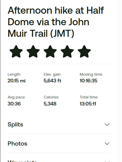 GPS/AllTrails stats from my hike
I slept in the next morning since I had all day to drive home. Before leaving town, I had a cinnamon roll for breakfast at the Cinnamon Roll Bakery & Cafe. I drove back through Yosemite, crossing the sierras over Tioga Pass road. Arriving midmorning at the park entrance station, I had to wait 45 minutes in line to get in. Even with permits required, there are just too many people.
While driving through the park, I stopped at a viewpoint where I could see Half Dome in the distance. It's one of the few places where there is a good view of the side with the cable route. I could visualize all the people that were going up the cables at that moment. If you zoom in on the photo I took from there, you can see what looks like a line of tiny ants on the side of the dome. After that stop, the rest of the trip was straightforward and I got home that night.
My stats from my GPS and the AllTrails app were 20.15 miles and 5,643 feet of elevation gain. From when I left my car till I got back was exactly 13 hours, even though my GPS said 10:16. It only counts time that you're moving and not when you stop. Apparently it thought the hour I spent struggling up the cables was just a long rest break.
I have to admit that I felt pretty good after doing this climb. It was like hiking 10 miles with over 5000 feet of elevation gain, then doing an hour long hard weight lifting workout in the gym, and then hiking another ten miles. Throw in my elevated heart rate on the cables due to the exposure to make me even more tired. And then don't forget the 5000 feet of elevation loss on the way back. As an engineer, I was completely amazed that my artificial knee could handle that. It's literally a miracle. This was definitely my hardest hike/climb in the mountains going back quite a few years. Not bad for a guy just short of his seventy second birthday.
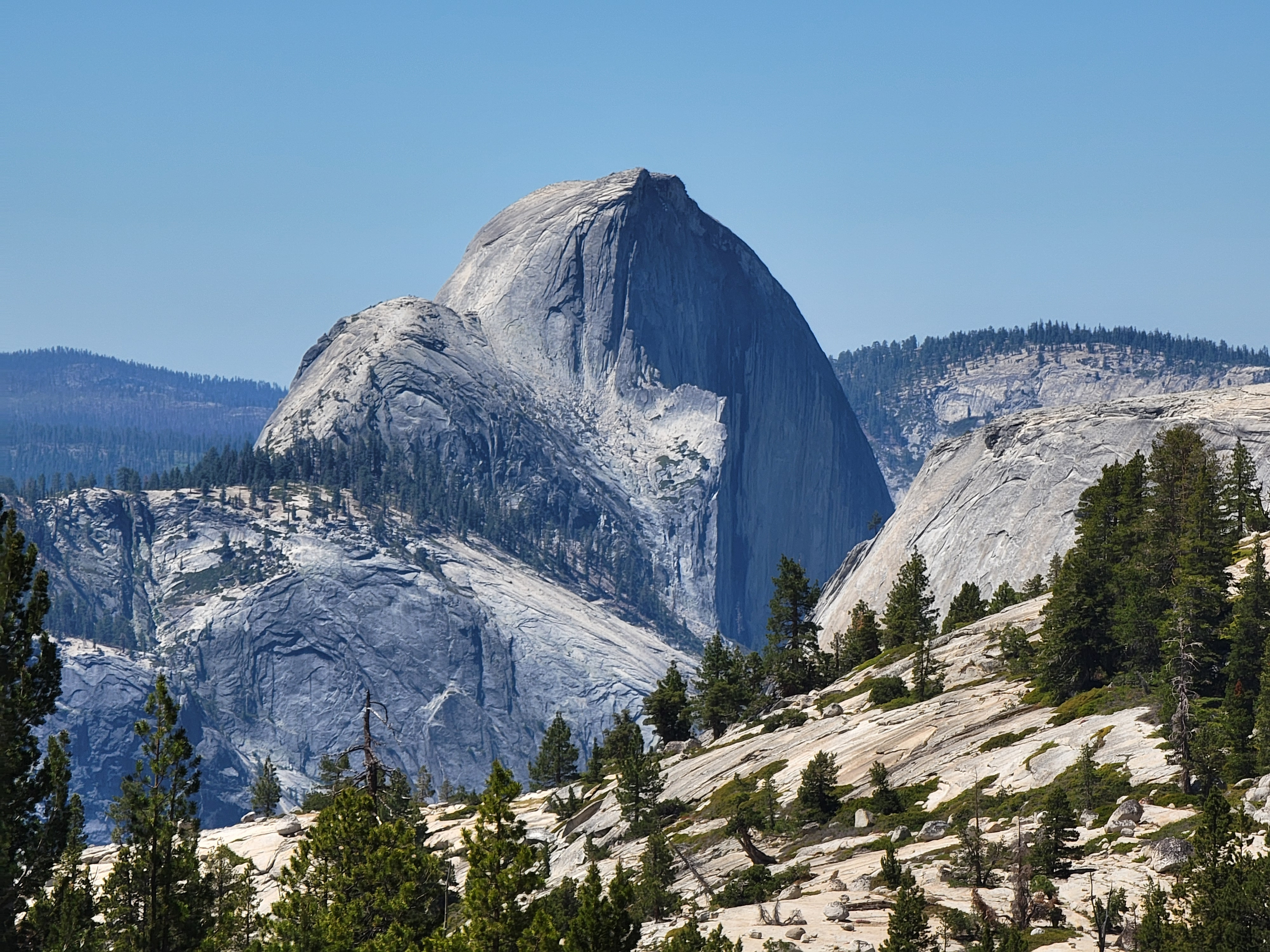 Zoom shot of Half Dome from Tioga Pass road viewpoint
In 1999, on my second climb of Half Dome with my sons Tim and Mickey, we met an old man on the trail. Talking to him we learned that he was ninety two years old. Later in camp we heard that he made it to the top of the subdome but not up the cables. Still, he has always been a hero to me, a tough old guy still doing hard hikes in his nineties. Something struck me afterwards. On my first climb of Half Dome, I was twenty three. On my second, I was forty six. Staying on a twenty three year cycle, I would be due again when I was sixty nine...and ninety two. Back then I thought, yeah, I'll do that.
Well, it's easy to commit to things that are twenty three years in the future. When I turned sixty nine, I actually did get a permit for Half Dome. But when the time came, I convinced myself that I was too busy, that it really wasn't worth doing. Wimpy excuses. Well, now I have fixed that. Three years late, but that much harder for the delay. So will I go back and climb Half Dome again when I'm ninety two? That sounds tough. It was all I could do to get up it this time. The record for the oldest person to climb Half Dome is likely held by Everett Kalin, who did it in 2023 at the age of 93. So am I going to keep my appointment with the mountain when I am 92? Probably not, but who knows? I thought that I had missed my third climb but now here I am.
Regardless of whether I go back to Half Dome again or not, this was one hell of a hard climb. I don't think I'm going to top this one for a while. I'm pretty proud of what I did.
